The Navy Museu, or Museu de Marinha, located in the tourist district of Belém is dedicated to all aspects of the history of Portuguese navigation, and is administered by the Portuguese Navy. It occupies a part of the neo-Manueline western wing of the Jerónimos Monastery, as well as a modern annex built to the north of the monastery.
 |
| The Navy Museu, or Museu de Marinha is located in the tourist district of Belém, and is part of the neo-Manueline western wing of the Jerónimos Monastery, as well as a modern annex built to the north of the monastery. |
The history of the museum is connected to King Luís I (1838–1889), who had a strong interest in oceanographic studies and was an accomplished navigator himself. In 1863, he began collecting items related to the preservation of the maritime history of Portugal, and the collection was enlarged in the following decades, culminating in the inauguration of the Maritime Museum in 1963 in its present location.
 |
| An impressive tapestry greets the visitor on entry to the museum portraying Prince Henry the Navigator at work. |
The exhibits include historical paintings, archaeological items and many scale models of ships used in Portugal since the 15th century, a collection of navigation instruments and maps, royal barges, as well as the Fairey III float-plane "Santa Cruz" that crossed the Atlantic in 1922, and the Portuguese Navy's first aircraft, an FBA Type B flying boat.
 |
| A chronological display of exhibits starts with models of the first Portuguese ships of exploration and trade in the 14t century. |
What follows is a by no means a comprehensive look at the collection of the museum as my own interests were quite specific, hoping to see the items relating to the early years of Portuguese maritime exploration, together with the development of their navy in the late 18th and early 19th century, and so I have not included a look at the models and items relating to the post ironclad and 20th/21st century navy, however a few other interesting items grabbed my attention so I hope this post might inspire others to check out this very unique collection of maritime exhibits.
 |
| Portuguese maritime trade routes during the Middle Ages. |
On entering the first gallery, there is a display of model ships capturing the look of the first Portuguese merchant ships that would have operated in the coastal waters of Portugal and indeed further afield as emphasised in the map above during the medieval period.
 |
| Model of a late 14th century merchant ship. |
From ancient times, Portuguese shores were visited by ships of many different peoples and from many origins, with the country's position a natural hub between the Mediterranean and Northern Europe, which promoted these contacts and the further development of maritime trade routes.
 |
| Barge - Small craft such as these were used in the early voyages of exploration, and it was probably this type of ship that was used by Gil Eanes when he first rounded Cape Bojador in 1434. |
Important trade routes were established in the Mediterranean with Catalonia, Genoa, Venice, and the North African coastal cities, but it was in the North Atlantic where maritime trade really prospered with several commercial treaties established with England, which facilitated a growing Portuguese presence in Europe's Atlantic littoral and North Sea Ports in Bordeaux, La Rochelle, Bruges, Hamburg and others.
 |
| A model of a small fishing boat, used in early voyages of exploration and referred to in ancient chronicles as a 'fishing-caravel'. |
This expanding mercantile trade and the prosperity it engendered encouraged further voyages of exploration and these early voyages were made in vessels such as those shown in the models above, commonly used in fishing as well as coastal maritime trading.
 |
| Cape Bojador in Western Sahara, first rounded by Portuguese explorer Gil Eanes in 1434. |
These small ships roughly divided into two main groups of 'lateen' rigged (with triangular sails) and the square rigged, but also including those with a mixture of both types as well as oars, eventually evolving into larger vessels with more complex rigging that developed into the famous Portuguese caravels and 'naus' or carracks (Note the Portuguese words 'caravel', 'naus' or 'nau' and 'carrack' all refer to ship in English but came to be terms to describe a particular ship).
 |
| A model of a 'Caravelão', a small lateen rigged vessel, similar to a caravel, but smaller. |
In the second half of the fourteenth century outbreaks of bubonic plague led to severe depopulation, and migration from the country led to the abandonment of agricultural land and an increase in rural unemployment, leaving only the sea offering opportunities, with most people settling in fishing and trading areas along the coast.
 |
| The Caravelão was mainly used as a support ship. |
Between 1325 and 1357 Afonso IV of Portugal granted public funding to raise a proper commercial fleet and ordered the first maritime explorations, with the help of the Genoese, under the command of admiral Manuel Pessanha.
 |
| This two masted lateen rigged caravel was known as the 'discovery caravel' as it was the main type of ship used in maritime exploration from 1440 until the end of the 15th century. |
In 1341 the Canary Islands, already known to Genoese seafarers, were officially rediscovered under the patronage of the Portuguese king, but in 1344 Castile disputed ownership of them, further propelling the Portuguese towards developing their navy. The first victims of slave raids by Portuguese and Spanish were the Guanches of the Canary Islands, a people of Berber origin, who put up fierce resistance but were reduced to near extinction by pillaging and enslavement.
 |
| A portrait identified as Prince Henry the Navigator (died 1460, aged 66), 15th century - Nuno Gonçalves. |
In 1415, the Portuguese occupied the North African city of Ceuta to gain a foothold in Morocco and control shipping through the Strait of Gibraltar, whilst, with papal funding, key to voyages of exploration in the Church's desire to extend Christianity these and other expeditions provided an outlet for Portuguese nobles looking to gain riches and honour in war.
Among the participants in the action was the young Prince Henry the Navigator, appointed governor of the Order of Christ in 1420, while personally holding profitable monopolies of resources in Algarve, he took the lead role in encouraging Portuguese maritime exploration until his death in 1460.
 |
King John II.
Called the Perfect Prince (Portuguese: o Príncipe Perfeito), was King of Portugal from 1481 until his death in 1495, and also for a brief time in 1477. He is known for re-establishing the power of the Portuguese monarchy, reinvigorating the economy of Portugal, and renewing the Portuguese exploration of Africa and Asia. |
In 1474, Prince John was assigned management of all aspects concerning the exploration of the Atlantic and the African trade established by his father King Alphonso V, and it was from this moment that a possible plan to reach India by sea became a major focus of Portuguese maritime exploration.
 |
| The resulting evolution of the two masted caravel, was the three mast lateen rigged caravel developed in the late 15th century. |
In 1481, the now King John II ordered the exploration along the African coastline in order to find a passage to the Indian Ocean, and following the voyages of Diogo Cão from 1482 to 1486, Bartolomeu Dias finally managed to sail around the southern most tip of Africa, thus opening the route to India, however King John would not live long enough to see the arrival of Portuguese ships in India three years later, himself dying on October 25th, 1495.
 |
| Also known as the 'fleet caravel' the square rigged caravel was developed in the 16th century and used as a support and war ship. |
In 1492 Christopher Columbus's discovery for Spain of the 'New World', which he believed to be Asia, led to disputes between the Spanish and Portuguese, which were eventually settled by the Treaty of Tordesillas in 1494.
 |
| The Treaty of Tordesillas in 1494 divided the known world outside of Europe into an exclusive duopoly between the Portuguese and the Spanish, based on a north-south meridian west of the Cape Verde Islands. |
The treaty effectively divided the world outside of Europe into an exclusive duopoly between the Portuguese and the Spanish, along a north–south meridian 370 leagues, or 970 miles, west of the Cape Verde islands. However, as it was not possible at the time to correctly measure longitude, the exact boundary was disputed by the two countries until 1777.
 |
| The fleet caravel displays the lines that would influence the later larger ships such as the great carracks and galleons. |
On the 8th of July 1497 a fleet of four ships, two carracks, the flagship S. Gabriel and the S Rafael; a caravel, the Bérrio and a small support ship, meant to be dismantled for spare parts for the other vessels, under the command of a certain Vasco da Gama departed from the River Tagus on a voyage of exploration to find a route to India.
 |
| This statue of the Archangel St Raphael was onboard the ship of that name that was part of Vasco da Game exploration fleet, and survived the wrecking of the ship on its homeward voyage, to be transferred to Vasco de Gama's ship and accompanying him on every subsequent voyage. In 1600 it returned to Portugal from India, brought home by Dom Francisco da Gama, the great-grandson of the famous seafarer. |
After a difficult ten month voyage, the Portuguese fleet reached its destination on the 20th May 1498, completing the first maritime connection to India.
 |
| The route followed in Vasco da Gama's first voyage (1497–1499) |
 |
| The carracks of Vasco da Gama's fleet like this one, a model of the S. Gabriel were purpose built for the trip. Of moderate dimensions, about 66 feet long and 120 tons displacement, they were thought sturdy enough to withstand a journey of unknown length and difficulty. |
Vasco da Gama's voyage to Calicut was the starting point for deployment of Portuguese feitoria posts (fortified outposts) along the east coast of Africa and in the Indian Ocean.
The Casa da Índia, effectively the Portuguese East India Company, was established in Lisbon to administer the royal monopoly of navigation and trade, however exploration soon lost private support, and would only continue under the exclusive patronage of the Portuguese Crown.
 |
16th century body armour
Gunners and soldiers manned the ships that made the India run, an annual Lisbon to India voyage on ships that became known as men of war. |
A second voyage to India was dispatched in 1500 under Pedro Álvares Cabral, and while following the same south-westerly route across the Atlantic Ocean as da Gama (to take advantage of the most favourable winds as shown below), Cabral made landfall on the Brazilian coast.
 |
| Wind patterns, generally remain fairly consistent and predictable around the globe and the Doldrums between the North East Trades and South East Trades in the South Atlantic was always a tricky area to navigate in the age of sail, with the former wind taking the early Portuguese explorers naturally towards the Brazilian coast before getting stuck in the Doldrums in search of any type of wind and attempting to tack southwest towards the aptly named Cape of Good Hope. |
This was probably an accidental discovery, but it has been speculated that the Portuguese secretly knew of Brazil's existence and that it lay on their side of the Tordesillas line.
 |
| Gunners not only manned the ships but also Portuguese fortresses and trading posts as well. |
Cabral recommended to the Portuguese King that the land be settled, and two follow-up voyages were sent in 1501 and 1503. The land was found to be abundant in pau-brasil, or brazilwood, from which it later inherited its name, but the failure to find gold or silver meant that for the time being Portuguese efforts were concentrated on India.
 |
| The development of Portuguese warship design continued into the 16th century with the advent of the galleon. |
Galleons were large, multi-decked sailing ships developed in Spain and Portugal and first used as armed cargo carriers from the 16th to 18th centuries and drafted for use as warships until the Anglo-Dutch Wars of the mid-17th century.
 |
| Portuguese Carracks, galleon, round square caravel and galleys, in the Route map of the Red Sea, depicted by João de Castro during the Portuguese expedition to Suez - Egypt, in 1541. |
Galleons generally carried three or more masts with a lateen fore-and-aft rig on the rear masts, were carvel built with a prominent squared off raised stern, and used square-rigged sail plans on their fore-mast and main-masts.
The Portuguese galleon was specifically designed for warfare and the protection of merchant Indiamen as well as imposing and maintaining Portuguese sovereignty in the Atlantic and Indian Oceans, being fast and manoeuvrable ships of low profile when compared to the merchant carracks and capable of carrying fifty guns of mixed types and calibre.
The 'taforeia' seen below was a versatile transport ship designed to carry horses and other war logistics, but also when needed able to perform the role of warship.
Several 15th century documents mention these ships in their descriptions of the warfare in North Africa, and by the 16th century were similar in size and shape to carracks or Indiamen.
Just two years after Vasco da Gama reached India by sea, the Portuguese realized that the prospect of developing trade such as that which they had practiced in West Africa had become an impossibility, due to the opposition of Muslim merchant elites on the western coast of India, who incited attacks against Portuguese feitorias (trading bases), ships, and agents, whilst also sabotaging Portuguese diplomatic efforts, that led to the massacre of the Portuguese in Calicut in 1500.
 |
Portrait of Dom Francisco de Almeida, Viceroy of Portuguese India (after 1545) Dom Francisco de Almeida, also known as the Great Dom Francisco (c. 1450 – 1 March 1510), was a Portuguese nobleman, soldier and explorer, and distinguished himself as a counsellor to King John II of Portugal and later in the wars against the Moors and in the conquest of Granada in 1492. In 1505 he was appointed as the first governor and viceroy of the Portuguese State of India, and is credited with establishing Portuguese hegemony in the Indian Ocean with his victory at the naval Battle of Diu in 1509. |
Thus, in response the Portuguese signed an alliance with a sworn enemy of Calicut and its ruler the Zamorin, the Raja of Cochin, who invited them to establish headquarters, that saw the Zamorin invade Cochin in response, but in return the Portuguese were able to devastate the lands and cripple the trade of Calicut, then the main exporter of spices back to Europe, through the Red Sea, followed up in December 1504 by the Portuguese destroying the Zamorin's yearly merchant fleet, bound for Egypt and laden with spices.
 |
| A cast-bronze, breech loading naval gun, from the period of King John III (1521-1557). It fired lead shots, with an effective range of about 450 yards, and was carried by the Portuguese carrack Santiago wrecked on the shallows of Judia (Indian Ocean) on her way to India in 1585. |
When King Manuel I of Portugal received news of these developments, he decided to nominate Dom Francisco de Almeida as the first viceroy of India with expressed orders not just limited to safeguarding Portuguese feitorias, but also to curb hostile Muslim shipping. Dom Francisco departed from Lisbon in March 1505 with twenty ships and his 20-year-old son, Dom Lourenço, who was himself nominated capitão-mor do mar da Índia or captain-major of the sea of India.

Portuguese intervention was seriously disrupting Muslim trade in the Indian Ocean, threatening Venetian interests as well, as the Portuguese became able to undersell the Venetians in the spice trade in Europe, and unable to oppose the Portuguese, the Muslim communities of traders in India as well as the sovereign of Calicut, the Zamorin, sent envoys to Egypt pleading for aid against the Portuguese.
 |
| The Citadel of Diu was an important commercial hub for the Red Sea and the Persian Gulf routes. The first fortification was built in 1535 and after two sieges it was rebuilt in 1547 and featured the first bastioned wall to facilitate heavy artillery in India. |
The response to the growing power of Portuguese control in the Indian Ocean saw an alliance established between the Mamluk Sultanate of Egypt, the main middleman between the spice producing regions of India, and the Venetian buyers in the Mediterranean with the Venetians able to bring their naval skills to combine with large numbers of Mamluk soldiers, as both parties sought to take "rapid and secret remedies" against the Portuguese.
 |
| March 1508 saw the Battle of Chaul between the Portuguese and Egyptian Mamluk fleets, that would spark the climax of a struggle for supremacy in India and the valuable spice trade at the Battle of Diu fought on 3rd February 1509. |
In March 1508 the naval Battle of Chaul was fought between the Portuguese under Dom Lourenço de Almeida and an Egyptian Mamluk fleet under Amir Husain Al-Kurdi in the harbour of Chaul in India, with the battle ending in a Mamluk victory and the death of Dom Lourenço and was the first Portuguese defeat at sea in the Indian Ocean.
Although a victory for the Muslim forces, the result of the two day battle was however largely pyrrhic, as Hussain lost between 600 and 700 out of a total of 800 soldiers and the remainder of his forces somewhat demoralised after their encounter with European weaponry.
 |
| This Commemorative Stone is from Diu Fortress and is dedicated to the Navy Captain, Caetano Correa de Sá, Governor of the Diu Fortress, where its was placed to celebrate the construction of a bastion as well as other works under his command. |
Upon hearing in Cochin of the death of his only son, Dom Francisco de Almeida was heart-stricken, and retired to his quarters for three days, unwilling to see anyone. The presence of a Mamluk fleet in India posed a grave threat to the Portuguese, but the viceroy now sought to personally exact revenge for the death of his son at the hands of Mirocem, supposedly having said that "he who ate the chick must also eat the rooster or pay for it".
Nevertheless, the monsoon was approaching, and with it the storms that inhibited all navigation in the Indian Ocean until September. Only then could the viceroy call back all available Portuguese ships for repairs in dry dock and assemble his forces in Cochin.
 |
| Afonso de Albuquerque, 1st Duke of Goa (c. 1453 – 16 December 1515), was a Portuguese general, admiral, and statesman. He served as viceroy of Portuguese India from 1509 to 1515, during which he expanded Portuguese influence across the Indian Ocean and built a reputation as a fierce and skilled military commander. |
Before they could depart though, on 6th December 1508 Afonso de Albuquerque arrived in Cannanore from the Persian Gulf with orders from the King of Portugal to replace Almeida as governor. Dom Francisco had a personal vendetta against Albuquerque, as the latter had been assigned to the Arabian Coast specifically to prevent Muslim navigation from entering or leaving the Red Sea. Yet his intentions of personally destroying the Muslim fleet in retaliation of his son's death became such a personal issue that he refused to allow his appointed successor take office. In doing so, the viceroy was in official rebellion against royal authority, and would rule Portuguese India for another year as such.
The Battle of Diu was fought on 3rd February 1509 in the Arabian Sea, in the port of Diu, India, between the Portuguese Empire and a joint fleet of the Sultan of Gujarat, the Mamlûk Burji Sultanate of Egypt and the Zamorin of Calicut.
 |
| The Battle of Diu was fought on 3rd February 1509. |
The “Battle of Diu” began at approximately 11 am on the 3rd February when the incoming tide and the dominant winds were favourable. The Portuguese deployed 18 ships, ranging from a brigantine to five big naus, to go up against up to 200 ships from the Mamluk-Gujarat-Calicut alliance. The Kurdish admiral was in command since the governor of Diu had already moved inland.
Francisco de Almeida commanded 18 ships carrying roughly 1,500 Portuguese soldiers and 400 Cochin native fighters. Only twelve of the 100 ships on the Muslim side were large ships while the remainder were modest, shallow-draught craft. The Egyptians chose to exploit the port of Diu and its fort, which had its own cannon, after spotting the Portuguese, who were coming from Cochin to the north as they were intimidated by the latter’s technological supremacy. Therefore, the decision was made to remain anchored in the port and wait for a Portuguese attack.

After launching a major naval bombardment with their onboard cannon, the Portuguese engaged in hand-to-hand combat in Diu’s harbour to begin the conflict. These Portuguese ships were better manned, better constructed, had superior artillery men and cannons of higher quality. The Portuguese naval infantry also had an advantage over the Egyptians since they were experienced, professional seafarers in addition to being well-armed and equipped (arquebuses, armour, and a kind of clay grenade with gunpowder within).
The Portuguese ships were equipped with arquebuses and crude grenades and had a sizable number of combatants who had been trained for maritime combat. The Turkish fleet marines were mostly archers and wore virtually no armour because they were prepared for combat in the Mediterranean. Additionally, it was nearly hard to board the Portuguese ships because they were higher in the sea. Additionally, any enemy vessel trying to approach them for boarding action could be bombarded by their gun.

The Turkish ships and the artillery batteries defending the harbour were heavily bombarded by the Portuguese. The Portuguese then intervened to confront the enemy after the Turkish and Gujarati ships refused to leave the harbour’s “safety,” as Almeida had predicted. During the next six hours, the Portuguese engaged the enemy ships with full broadsides, grappled and boarded them, and captured two Turkish naus, two Gujarati naus, and the two Turkish gales in brutal hand-to-hand combat, demonstrating the superiority of the state-of-the-art European vessels.
Two Turkish caravelas, two Gujarati naus, and two Turkish naus were also sunk. When the wind started to shift at five o’clock, Almeida gave the order for his fleet, which had not lost any ships despite one of his naus suffering significant damage, to depart the harbour with some of its loot. In the end, the better ships prevailed
 |
| Bronze-cast guns became the main naval ordnance by the early 16th century. In Portugal the manueline (developed under King Manuel I) "Berço" (Breech-Loading Swivel Gun) or "Verse" is the main gun type during this period, due to its effectiveness, versatility and quantity produced. Along with larger versions such as the "falcão" and "falconete", these cannons were extensively used on board ships or for defence of the Portuguese maritime fortresses. |
The whole Mamluk fleet was either destroyed or taken prisoner before the end of the day. Hussain Amir escaped inland, leaving the Portuguese with a victory that was a battle of annihilation similar to the Battle of Lepanto and the Battle of Trafalgar, and one of the most important in world naval history, marking the beginning of European dominance over Asian seas; resulting in the Kingdom of Portugal rapidly capturing several key ports in the Indian Ocean including Goa, Ceylon, Malacca, Bom Baim and Ormuz and the territorial losses crippling the Mamluk Sultanate and the Gujarat Sultanate, whilst catapulting the growth of the Portuguese Empire and establishing its political dominance for more than a century.
 |
| This demi-culverin bronze cannon, cast between 1580 and 1589, belonged to the fortress of Diu. |
Portuguese galleons were designed for both military and trade purposes, serving as armed cargo carriers and warships to protect merchant ships and enforce Portuguese sovereignty in the Atlantic and Indian Oceans.
This superb cutaway model illustrates the development of this ship-type from the earlier models shown, with its spacious hold, and bristling with twenty modern guns for the period, mounted well above the waterline, almost a forerunner for the typical Indiaman that would develop in the later 18th and 19th centuries.
 |
| The gun at the back is a bronze naval gun recovered from the seabed in 1968 off Lourinhã, Portugal, and might have been carried by the flagship of General Tristão de Mendonça Furtado's fleet , the galleon S. Nicolau lost in combat and sunk nearby in 1642. |
In 1543, Portuguese explorers landed in the southern archipelago of Japan, becoming the first Europeans to the country later followed by Portuguese traders and merchants looking for trading opportunities.
 |
One of the first Luis Teixeira maps of Japan Iaponia Insvla. 1598. Cartographer: Abraham Ortelius. Printed in Antwerp by Pieter Heyns. |
This period of time is often entitled Nanban trade, where both Portuguese and Japanese would engage in mercantilism and cultural exchange, and the Portuguese at this time would found the port of Nagasaki, through the initiative of the Jesuit Gaspar Vilela and the Daimyo lord Ōmura Sumitada, in 1571, where the annual trade ships arrived from then on.
 |
| Katanas, Samurai Japanese swords - The upper sward is not homogenous, the blade and the hand-guard are probably dating from the 16th century while the remaining parts were added in the 19th century. The lower weapon is entirely dated from the 18th century. |
 |
| Muzzle loading matchlock harquebuses of Japanese origin - Initially designated as "Tanegashima" and later as "Teppo", these fire arms were widely reproduced by the Japanese according to the model of those offered to Lord Tanegashima by the Portuguese when they first arrived in 1543. |
Between 1996 and 1997 archaeological excavations were conducted in an area close to the São Julião de Barra fortress on the Tagus river, an important graveyard for shipwrecks, focussed on the remains of a Portuguese East-Indiaman thought to have been the Nossa Senhora dos Mártires, wrecked on the 15th September 1606 on the final stretch of her homeward voyage from Kochi, India.
 |
| The treasures recovered from a late 16th century Portuguese Indiamen, recovered in the Tagus River, 1996-97. |
As well as revealing details on the structure and dimensions of a late 16th century Portuguese Indiamen the excavation revealed a number of artifacts as seen above casting light on the products of maritime trade, as well as life on board for both passengers and crew, evoking the lives of those so often lost on such perilous voyages.
 |
| A pair of Indo-Portuguese gold ear-rings, shaped like stylised satyr heads and half moon pendants with pearls. |
 |
| Copper alloy nautical compasses. |
 |
| A small Japanese sabre with copper alloy guard from the Momoyama period (1573-1603). |
 |
| 17th century Spanish silver coins. |
Portuguese Navigational Inventions, and MapmakingBy means of ancient nautical instruments, pioneering navigators such as Ferdinand Magellan, Bartolomeu Dias and Vasco da Gama somehow managed to find their way by the stars.
 |
| Known since ancient times, the armillary sphere is an instrument used for astronomical calculations and the study and representation of the cosmos. Usually composed of five parallel rings (or 'armilas') which represent the equator, in the centre, and the tropics and polar circles intersected by an oblique ring representing the various constellations of the zodiac with at its axis a sphere representing the Earth. |
During the Age of Discovery, the astrolabe was, along with the quadrant and cross-staff, the best way for ships on the high seas to determine their latitude by using the position of the stars; and Portuguese navigators used them to measure the altitude of stars with this information enabling them to establish their latitude. But they had no means of finding their longitude, having to rely only on experience and intuition to determine their exact position, a problem that was not solved until three centuries later with the invention of the chronometer.
 |
| Astrolabe 'Aviero' of Portuguese origin, dated to 1575, and recovered from a shipwreck in the Ria de Aviero, Portugal. |
 |
| A selection of 16th and 17th century astrolabes recovered from wrecks of Portuguese and Spanish galleons and Indiamen. |
Astrolabes were first constructed by the Arabs and were widely used for various purposes towards the end of the Middle Ages. However, it was the Portuguese who simplified and adapted their use for sea navigation, creating the nautical astrolabe from its flat, medieval precursor. Many Spanish navigators preferred Portuguese-made astrolabes to their own.
 |
| A planispheric astrolabe of French origin made by Nicol Patenal and dated 1616 (left) and a similar instrument dated circa 1500 (right) |
Mapmakers, greatly interested in the development of these instruments for use at sea, were responsible for successive improvements in their design and weight.
 |
| The mariners astrolabe consists of a simplified version of the pianispheric astrolabe, since it was meant to be used at sea. It was used to measure the angle between the vertical (zenith) of the observer and the position of the sun at solar noon, and with additional calculations, it enabled the determination of the ship's latitude and thus an indication of the ship's position at sea. |
Navigating by astrolabe required skill and knowledge. It was known that the latitude of a position was equal to the altitude of the Pole Star. However, the Pole Star, which is today about one degree off the Pole, was approximately three and a half degrees from the Pole at the end of the 15th and beginning of the 16th centuries.
This meant that corrections had to be made to determine a ship’s true latitude. As ships sailed close to the equator, the Southern Cross was substituted for Ursa Minor, which was lying very low in the sky at this point, for navigational purposes. This method of determining latitude developed by Portuguese navigators was known as the Southern Cross Regimen.
 |
Considered one of the greatest mathematicians of his time, Pedro Nunes (1502-1578) was a Portuguese mathematician, cosmographer, and professor, best known for being the first to approach navigation and cartography with mathematical tools, being the first to propose the idea of a loxodrome (a rhumb line), and was the inventor of several measuring devices, including the nonius (from which the Vernier scale was derived), named after his Latin surname. |
The Southern Cross constellation, however, was often difficult to see and as voyages in the southern hemisphere increased, Portugal discovered and put into use a method of determining latitude from the meridian altitude of the sun.
Unlike the Pole Star and Southern Cross, the distance from the sun to the Pole varies throughout the year, making the means of navigating by the sun more complex. Given the meridian altitude of the sun, it is still necessary to know its distance from the Pole. In the southern hemisphere, this means knowing the distance to the equator or the angular difference, or declination, in order to determine the ship’s latitude.
The Nonius is a measuring tool used in navigation and astronomy and was created in 1542 as a system for taking finer measurements than on circular instruments such as the astrolabe, permitting finer readings than the one or half-degree settings that were the smallest possible until then. The system was eventually adapted into the Vernier scale in 1631 by the French mathematician Pierre Vernier.
 |
| A replica Quadrant with 'Nonius' invented by Pedro Nunes. |
Pedro Nunes also invented the ‘nautical ring’, used for taking readings from the sun, and the ‘shadow instrument’ that enabled navigators to determine the altitude of the sun without looking directly at it.
 |
| Astronomical or Graduated Ring (replica). |
 |
| A replica 16th century Shadows Instrument invented by Pedro Nunes, was designed to measure the altitude of the Sun, for the determination of latitude. Properly orientated, it indicates the altitude by the shadow of the hypotenuse of the triangle over the graduated scale. |
 |
| Replica quadrant and cross-staff, the former used at least since the 15th century for the determination of latitude, through the observation of the North Star, initially made of wood but later of brass or bronze; and the later instrument used during the 16th and 17th century for measuring the altitude of the stars in the calculation of latitude. |
As well as their contribution to mariners navigational tools the Portuguese were also producing the first nautical charts mapping the new parts of the world they discovered that would form the basis of the charts later mariners and explorers would refer to in later centuries.
Luís Teixeira or Ludovico Teixeira was a 16th-century Portuguese, cartographer, and mathematician. He had two sons, also cartographers.
Teixeira contributed a well-known early map of Japan (Iaponiae Insulae Descriptio) to Abraham Ortelius's atlas Theatrum Orbis Terrarum, and it was the first separate map of Japan, and was for many years the standard map of Japan used by Europeans (until the 1655 map by Martino Martini).
 |
| A Nautical Chart of the North and South Atlantic, made by Luis Teixira. |
The nautical chart seen above is of the North and South Atlantic, and was made by Luis Teixira, this being a copy of an original on parchment held by the Biblioteca Nazionale Centrale in Florence, Italy.
Jorge Reinel (c. 1502 – after 1572) was born in Lisbon, the son of the well-known cartographer Pedro Reinel and was a Portuguese cartographer as well as an instructor in cartography. In 1519 in Seville he participated in the maps designed for the trip of his countryman Ferdinand Magellan, and his depiction of the Maluku Islands served as a basis for Spanish claims to the islands.
 |
| A Nautical Chart of the South Atlantic and Indian Ocean, thought to have been created by Jorge Reinel. |
The nautical chart above is of the South Atlantic and Indian Ocean, and though not signed bears certain features that indicate it was created by Jorge Reinel, and it is the oldest known chart that references Diu, India and Malacca, Malaysia.
 |
| A copy of a 16th Century chart of the North Atlantic - Bayerische Staatsbibliothek, Munich, Germany. |
The copy of the chart above of the North Atlantic from the 16th century is the earliest known chart of this part of the Atlantic and is signed by Pedro Reinel, with the detail toponomy of Newfoundland, Canada attributed to the voyages of Gaspar Corte-Real's voyages of 1500-1501.
 |
| A copy of Terra Brasilis - Original on parchment held by Bibliothèque Nationale de France. |
In the chart above, Terra Brasilis from the 1519 Atlas made by the Portuguese cartographers Lopo Homem and Pedro and Jorge Reinel, illustrated by Antonio de Holanda, we are presented with a stunning illustration of the Brazilian territory, emphasising its importance during the 16th century for supplying Brazilian hard woods.
 |
A wonderful terrestrial globe, circa 1645, made in the workshop of Willem Jansz Blaeu (1571-1638),
the most famous Dutch globe maker. |
18th and 19th Century Portuguese Naval Development
During the reign of King John V of Portugal, the Navy underwent a large transformation, as warships started being differentiated from merchant ships, and in 1705, a squadron of eight ships of the line was sent to help England (note: the Kingdom of Great Britain between England and Scotland was formed on the 1st May 1707) against the Franco-Spanish forces that were besieging Gibraltar during the Spanish war of succession 1701-14, this expedition culminating in the naval battle of Cabrita Point.
 |
| The Battle of Cabrita Point, also known Battle of Marbella - Copper engraving, uncoloured as published. Decorative scenes of the Spanish war of succession 1701-14. |
The battle ended in an allied victory (English, Portuguese and Dutch) which effectively ended the Franco-Spanish siege of Gibraltar.
 |
| A 24-pounder fortress gun from 1737. |
The 24-pounder fortress gun seen above dates from the reign of King John V and is Dutch, cast in bronze by Ciprianus Cranz in 1737; and was used to arm the Fort of São Lourenço do Bugio at the mouth of the Tagus River, now repurposed as a light house.
 |
| The Torre do Bugio, formerly a fort in the mouth of the Tagus River, Lisbon. |
King John's navy would also be called on to support the struggle against Ottoman expansion in the Eastern Mediterranean at the Battle of Cape Matapan, which took place on the 19th July 1717 off Cape Matapan, on the coast of the Mani Peninsula, now in southern Greece; and was fought between the Armada Grossa of the Republic of Venice, supported by a mixed squadron of allied ships from Portugal, the Papal States and Malta, and the Ottoman fleet, under Kapudan Pasha Eğribozli Ibrahim Pasha.
 |
| The Battle of Cape Matapan, 19th July 1717. |
The twenty-four Venetian sailing ships under Marcantonio Diedo, commander of the Venetian fleet, met up with another Venetian squadron of twenty-four galleys and a small squadron of nine mixed Portuguese-Maltese ships near Cape Matapan on the 2nd July, and after trying to win the wind gauge, and running out of water supply, the Allied force tried to reach Sapientza, but with the winds against them went to Marathonisi to resupply.
 |
| An 8cm calibre breech-loading naval stone-shot swivel gun in bronze and dating back to 1679. |
On the 19th July, the Ottoman fleet, with thirty sailing ships, and four galleys, was seen to the south, on the west side of the bay entrance, with a light wind from the SSE, that meant that they had the advantage, and thus Diedo, unable to sail to the west of the Ottoman fleet, decided to sail slowly east, across the bay, and at about 6am Ibrahim with six ships attacked the Rear Division, while the rest of his fleet went ahead and attacked the Van and Centre.
 |
The naval battle of Cape Matapan, 19th July 1717, a copy of an original painting by António José Ramos. |
At about 12pm the fleets were approaching the east side of the bay, and shortly after the leading ships turned, the wind turned from the SE, putting the leading Venetian ships to windward of some of the Ottoman fleet for the first time. Taking advantage of this, Diedo attacked them and the tough battle continued. At about 3pm the Ottoman fleet retired, sailing for the Cervi-Cerigo passage, while the Allies sailed for Cape Matapan. Neither side wished to continue the fight, and as a result of the battle, the Venetian attempt to recapture the Morea (the Peloponnese peninsula) was foiled and the Ottoman reconquest of the peninsula was confirmed.
The superb model seen in the photos below is of the fourth-rate 44-gun Principe da Beira, built at the Lisbon Navy Arsenal in 1774 and during her career made several voyages to Brazil, India and China.
 |
| The 44-gun Principe da Beira, built in 1774. |
It is recorded that during her time on the China-run, her commander established a fearsome reputation with pirates operating in the South China Sea, who made it their business to avoid meeting her as a consequence, and earning her commander the nickname 'The Tiger'.
The museum is home to some other beautiful models, one of which, seen below is of the 44-gun frigate Ulysses (1792-1809), launched on December 15th 1792 and operated alongside the British fleet under the command of Lieutenant General José Sanches de Brito.
 |
| The 44-gun frigate Ulysses (1792-1809). |
In 1798 she was on escort duties, part of a five ship squadron under Squadron Commander Francisco de Paulo Leite, successfully escorting a 122 ship convoy from Brazil to Lisbon in October of that year.
 |
Squadron Commander Francisco de Paula Leite de Sousa, Viscount of Veiros.
|
Leite enjoyed a very successful career in the navy and would transfer to the Portuguese army in 1799 with the rank of Field Marshall, and according to the great historian Sir Charles Oman, of all the Portuguese commanders, Leite was the one whom Wellington most trusted and "every British narrator of the war who came in contact with him has a word of praise in his behalf".
In 1804 the Ulysses went through a major refit and was renamed Urania, and on the 27th November 1807 joined the squadron that transported the Portuguese Royal Family to Brazil during the French invasion.
Urania was lost on the 5th February 1809 near Cape Verde on a voyage from Rio de Janeiro to England.
Born on December 30th, 1765, Domingos Xavier de Lima, 7th Marquis of Nisa joined the Portuguese Navy at age 15, serving aboard the 74-gun
Nossa Senhora do Pilar. In 1782 he attended the recently created Royal Naval Academy and in 1783 he embarked on the ship
Nossa Senhora do Bom Sucesso and then on the frigate
São João Baptista, both of which were part of the Coast Guard Squadron.
 |
| The 74-gun Nossa Senhora do Pilar. |
At the age of twenty, he had his baptism of fire in the attack on Algiers, as part of the joint punitive expedition of Portugal and Spain against Algerian pirates. This expedition would provide him with the first opportunity to prove his worth, earning him the appointment as chief of staff of the Portuguese squadron, and later promotion to Captain-Lieutenant.
 |
| Domingos Xavier de Lima, 7th Marquis of Nisa and Portuguese naval commander in the Mediterranean 1798 to 1800. |
On 16th December 1791, now with the title of Marquis of Nisa, he was promoted to Captain-of-Sea-and-War and given command of the frigate São Rafael, of 44 guns, and in May of 1793, he joined the 74-gun Vasco da Gama in command of a squadron sent to aid the British in the English Channel at the request of the British government and consisting of six ships, two frigates and two brigantines.
By June 1797 he was promoted to Chief of Squadron, followed by his second command of a naval force on 23rd July consisting of seven ships: the Príncipe Real (ex- Nossa Senhora da Conceição ), Rainha de Portugal , Afonso de Albuquerque , Medusa and São Sebastião , the frigate Andorinha , and the brigantine Lebre, with his squadron operating south, as far as the Strait of Gibraltar protecting Portuguese merchant shipping from Barbary pirates, and cooperating with British Admiral John Jervis in actions against the French Mediterranean squadron.
 |
| Royal Portuguese Navy Officer's sword belonging to Commander of the Fleet, Admiral Domingos Xavier de Lima, 7th Marquis of Nisa. |
In the wake of the Battle of Cape St Vincent 14th February 1797, Britain reinforced its squadron in the Mediterranean, which was swelled with a Portuguese naval force commanded by the Marquis of Nisa, consisting of the ships
Príncipe Real (flagship, with 90-guns) and
Rainha de Portugal 74-guns, joined at sea by the
Afonso de Albuquerque and
São Sebastião both 64-guns, the frigate
Benjamim 26-guns and the brig
Falcão 24-guns, which set sail from Lisbon on the 5th May 1798, bound for Lagos, and later the Azores to protect a convoy coming from America.
On 30th June Nisa returned to Lagos, and received instructions from Admiral Jervis to cross the Straits of Gibraltar and join Nelson's force, who would also be the commander of the joint squadron, as he had the largest number of ships.
 |
| The Portuguese warship Queen of Portugal, part of the Marquis of Nisa squadron, and the squadron of Admiral Ball meet during the blockade of Malta, in October 1798. The Portuguese are shown making the required gun salute - Alberto Cutileiro, Museu de Marinha, Lisboa, Portugal. |
Nelson did not in the end meet him following the Battle of the Nile, and during the voyage the Portuguese squadron lost the brig Falcão, which, due to poor manoeuvring, rammed the Príncipe Real and sank within a few minutes, with all but six men of the crew being rescued.
It seems relations between the British and Portuguese squadrons became somewhat strained after the Portuguese contingent took offence at the rather haughty approach of some British naval commanding officers, such as Hood, Ball and later Nelson, with the former two failing to have their ships offer the required gun salute due to a senior officer of another allied nation's squadron and the latter for publishing a service order that considered Portuguese division chief officers to be hierarchically inferior to British Captains-of-Sea-and-War, which as well as being disrespectful was a complete break in recognising the equivalences between the respective hierarchies.
 |
| The Marquis of Nisa's pocket watch, gold plated and decorated with enamel figurative paintings on the lid and display. The watch was made in Switzerland by Bourquin, Le Jeune in the late 18th century and features a bass key and a circular border decorated with gem stones. |
As well as commanding the Portuguese squadron supporting the British blockade of Malta, Nisa, in April 1799, led a semi-diplomatic to the Bey of Tunis to persuade them along with a show of force to desist from attacking allied shipping and instead turn their attentions to the French which had the desired effect.
Relations with the British improved and in May 1799 the two forces cooperated successfully under Nelson to prevent attempts at a French relief of Malta and support the Neapolitan forces holding Naples, and by December with the withdrawal of the Portuguese ships for home escort duties the contribution of Nisa's Portuguese squadron in the blockade of the French garrison on Malta was recognised on his return to Lisbon with official recognition by the British Crown in a Royal Charter on the 6th June 1800.
 |
A Gunnery Officer and Infantry Soldier of the 1st Division of the
Royal Naval Brigade c1814. |
At the end of 1800 Nisa was appointed ambassador to the court of Tsar Alexander I of Russia and arrived in Russia just before the coronation, which he attended.
On his return to Portugal, he contracted smallpox in Konigsberg, which he did not survive, and on the 30th June 1802, the Marquis of Nisa, Admiral of the Portuguese Fleet and gentleman of the chamber of D. Maria I, died.
 |
It is interesting to see that these Portuguese marines are shown wearing
the Portuguese style Barretina shako in 1814 when their army comrades were
almost exclusively wearing the British style stovepipe by this time. |
A classic representation of the naval war during the French Revolutionary and Napoleonic Wars are the amazing carved bone models of men-of-war made by French prisoners of war, the one below depicting a British first-rate ship of the line and the model made in Woolwich on the Thames, London.
 |
| These prisoner of war models are an inspiration to me, when you consider the level of detail worked into these amazing pieces of art. |
The Liberal Wars, also known as the War of the Two Brothers and the Portuguese Civil War, was a war between liberal constitutionalists and conservative traditionalists in Portugal over royal succession that lasted from 1828 to 1834.
 |
Peter I versus his brother Miguel I
A contemporaneous cartoon, showing the conflict between the Two Brothers, as children, supported and instigated, respectively, by the French King Louis Philippe I, representing the liberal side, and Czar Nicholas I of Russia, representing the anti-liberalist Holy Alliance. |
The war would draw in other interested parties that included the Kingdom of Portugal, Portuguese rebels, the United Kingdom, France, the Catholic Church, and Spain, with half the liberal army composed of French, British, Spanish and Belgian soldiers.
 |
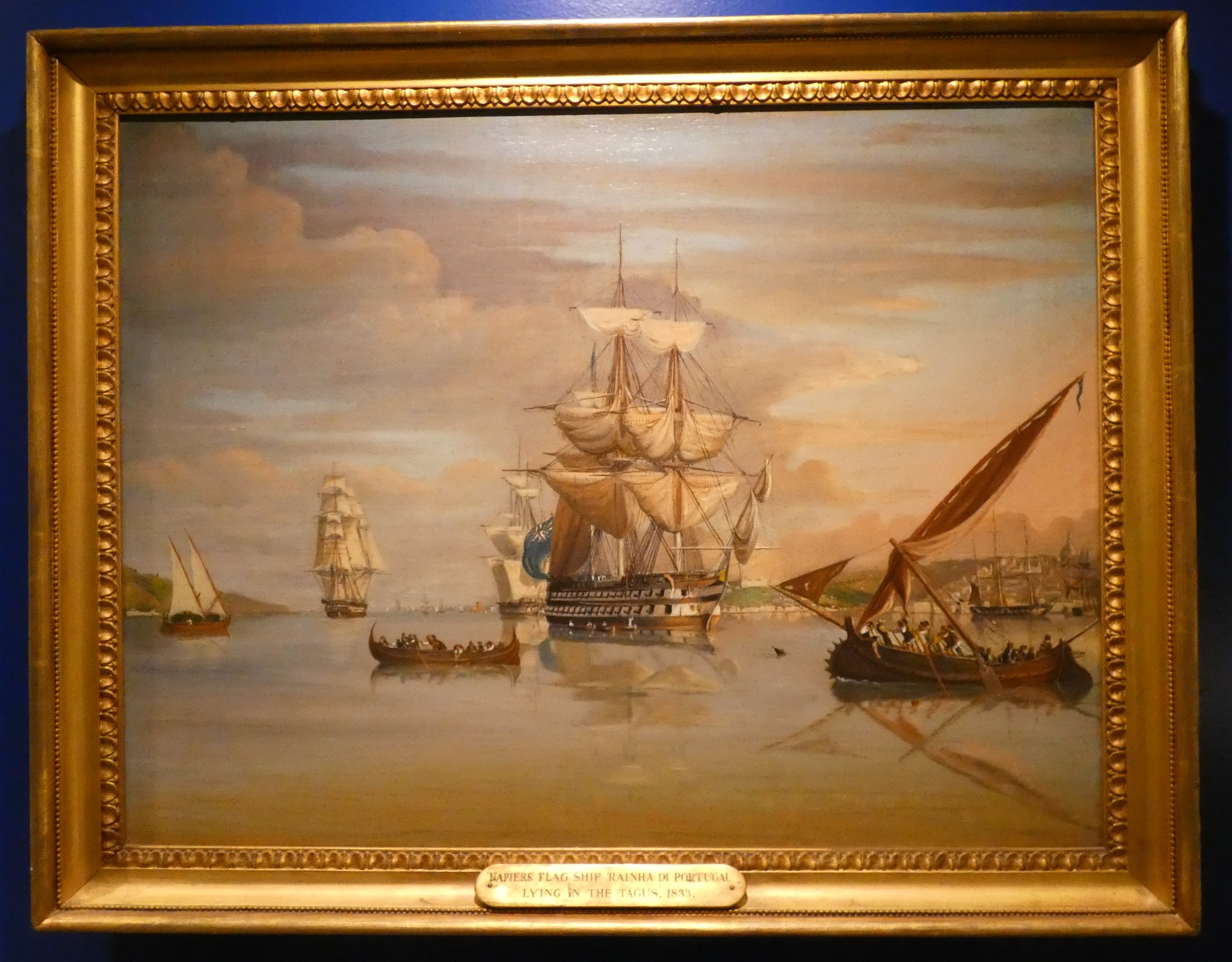
| Admiral Sir Charles Napier's flag ship, the frigate Rainha di Portugal, at anchor in the Tagus 1833. |
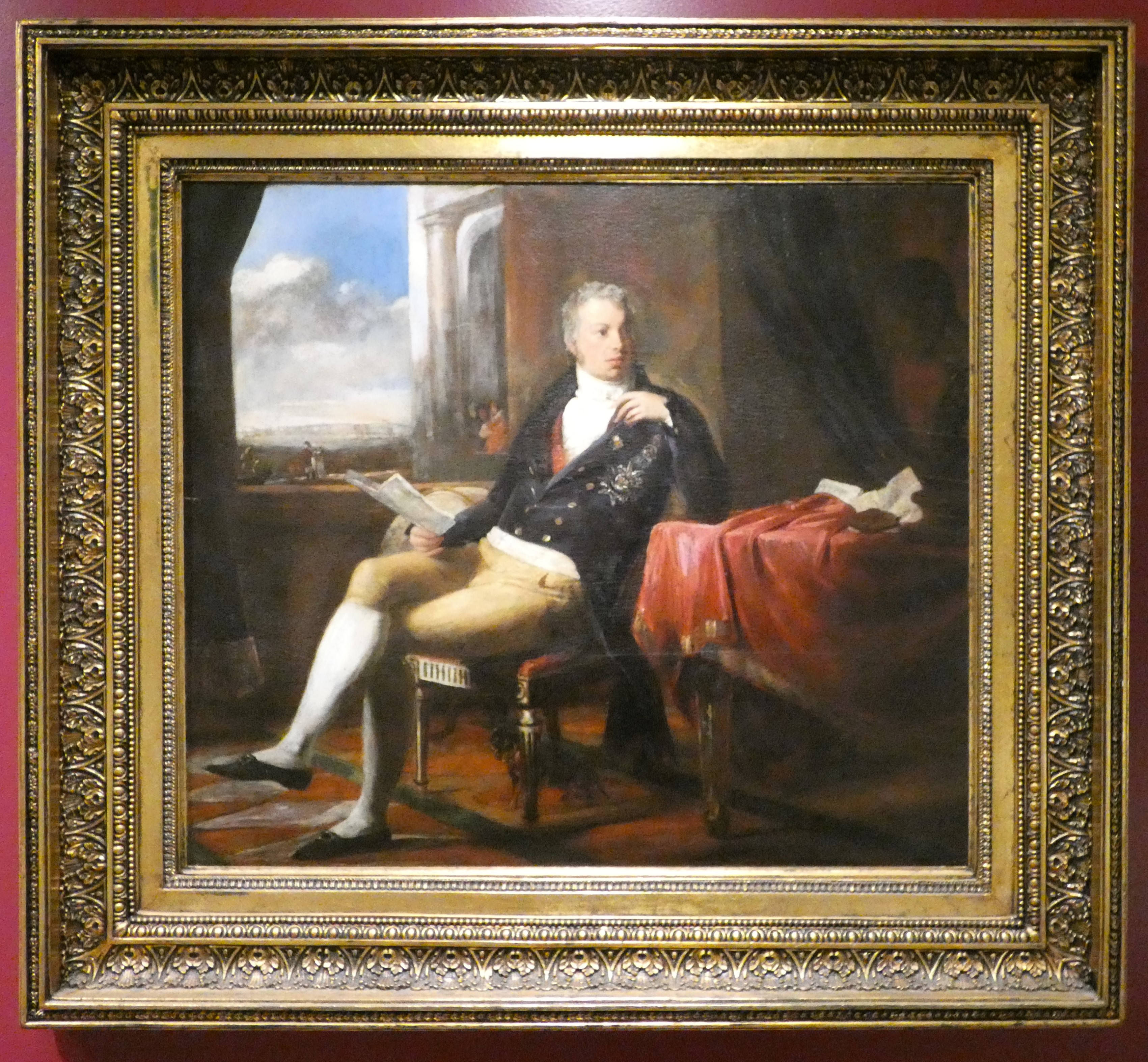
In June 1833, the Liberals, sent to the Algarve a force commanded by the Duke of Terceira supported by a naval squadron commanded by Charles Napier, using the alias 'Carlos de Ponza'.
,_after_1834,_Museu_Nacional_Soares_dos_Reis.png) |
| Admiral Sir Charles John Napier KCB GOTE (6th March 1786 – 6 November 1860) was a British naval officer whose sixty years in the Royal Navy included service in the War of 1812, the Napoleonic Wars, Syrian War and the Crimean War, and a period commanding the Portuguese navy in the Liberal Wars. |
The Duke of Terceira landed at Faro and marched north through the Alentejo to capture Lisbon on July 24th. Meanwhile, Napier's squadron encountered the absolutists' fleet near Cape Saint Vincent (Cabo São Vicente) and decisively defeated it at the fourth Battle of Cape St. Vincent.
 |
Naval battle of Cape St Vincent 5th July 1833 - Antoine Léon Morel-Fatio
Napier's flag ship Rainha de Portugal is shown boarding a Miguelite ship of the line at the height of the battle. |
The Battle of Cape St. Vincent was fought on the 5th July 1833 that saw over the course of the battle, the Liberal fleet, (3 frigates, 1 corvette, 1 brig and 1 schooner) despite being significantly outnumbered by the Miguelite fleet (4 ships of the line, 1 frigate, 1 xebec, 3 corvettes and 1 brig), and lacking any ships of the line compared to the Miguelite four, managed to close with the Miguelites, board their ships and engage in hand-to-hand combat; this following the early exchanges of cannon fire between the two fleets which went on for some time before Napier decided that his numerically inferior squadron could not last long against the Miguelite fleet, and sailed his ships directly towards them.
 |
| Model of a 24-gun frigate, redesignated 'Fragatinha' or 'Small Frigate' to include 24-gun and 32-gun types. |
This decision by Napier was the deciding factor in the outcome of the battle, and the Miguelite crews proved no match for the Liberal crews, most of them being former Royal Navy personnel that had been discharged and sought service under Pedro I of Brazil. The battle resulted in four Miguelite ships of the line, one frigate and one corvette being captured, and the remainder of the Miguelite fleet retreating from the engagement.
The battle had a decisive effect on the war, since the Miguelite fleet at Cape St. Vincent was the last significant naval force that Don Miguel could muster, his other naval forces being lost in the Battle of the Tagus on 11th July 1831 against a French fleet led by Albin Roussin, and the Miguelite-held Lisbon, deprived of any chance to be resupplied via the sea, quickly capitulated.
The model below is of the 46-gun frigate Rainha de Portugal (1831-1851), and was formerly British before her sale to the Portuguese Liberals in 1831, and was the flag ship of the Liberal Squadron assembled in the Azores to support the landing at Mindelo Beach near Porto on the 8th July 1832.

On the 5th July 1833 she took part in the Battle of Cape St Vincent where the Absolutist's naval forces were decisively defeated.
 |
| Note the colours carried on the stunning model, namely the vertical bi-colour in blue and white, bearing the Portuguese coat of arms and those flown by Napier's squadron at the Battle of Cape St Vincent. This flag was the flag of Portugal from 1830 to 1910. |
The pictures below illustrate the weapons carried aboard ship during the Napoleonic and Liberal Wars,
with the ubiquitous Tower Pattern 'Brown Bess' musket, perhaps the 19th century equivalent to the AK47 of modern times, to the fore, but with the Tower Pattern Pistol showing the replacing of the flint lock with a new modern percussion cap lock.
 |
| The gallery leading into the collection of models from the ironclads to modern ships of the Portuguese navy. |
I however continued on past various other items in the collection to arrive in the modern extension to the museum that houses a remarkable collection of royal barges together with significant aircraft that feature in the history of the Portuguese Navy.
However, easily missed if the eyes are immediately focused on the barge collection, were two very interesting remnants of large naval guns dating back to the Seven Years War and more precisely 1759, close by the doors on entering the new gallery.
 |
The battle off Lagos, August 18th, 1759 - Richard Paton. The British fleet under Admiral Edward Boscawen of 15 ships of the line, 10 frigates and 2 sloops pursued the Comte de La Clue's French fleet, 12 ships of the line and 3 frigates into the bay off Lagos after engaging the French south-west of Cadiz, destroying two ships of the line and capturing three more. |
The naval Battle of Lagos took place between a British fleet commanded by Edward Boscawen and a French fleet under Jean-François de La Clue-Sabran over two days in 1759 during the Seven Years' War, fought south west of the Gulf of Cádiz on the 18th August and to the east of the small Portuguese port of Lagos, after which the battle is named.
 |
A piece of one of the 36-pounder long guns cast in bronze and carried aboard the French flag ship
L'Océan. The remains were recovered from the wreck of the ship in 1969. |
La Clue was under orders to sail for the West Indies and attempting to evade Boscawen and bring the French Mediterranean Fleet into the Atlantic, avoiding battle if possible; whilst Boscawen was under orders to prevent a French breakout into the Atlantic, and to pursue and fight the French if they did.
_RMG_BHC2565.tiff.jpg) |
| Admiral Edward Boscawen (1711-1761) - Joshua Reynolds. |
During the evening of 17th August the French fleet successfully passed through the Strait of Gibraltar, but was sighted by a British ship shortly after it entered the Atlantic. The British fleet was in nearby Gibraltar, undergoing a major refit. It left port amidst great confusion, most ships not having their refurbishments completed, with many delayed and sailing in a second squadron. Aware that he was pursued, La Clue altered his plan and changed course; half his ships failed to follow him in the dark, but the British did.
.svg.png) |
| La Clue was attempting to evade Boscawen and bring the French Mediterranean Fleet into the Atlantic, avoiding battle if possible; he was then under orders to sail for the West Indies. Boscawen was under orders to prevent a French breakout into the Atlantic, and to pursue and fight the French if they did. |
The British caught up with the French on 18th August and fierce fighting ensued, during which several ships were badly damaged and one French ship was captured. The British pursued the remaining ships through the moonlit night of 18th–19th August, during which two French ships made their escape. On 19th August the remnants of the French fleet attempted to shelter in neutral Portuguese waters near Lagos. Boscawen then captured a further two French ships and destroyed another two.
These pictures are of the remains of two cannon carried aboard La Clue's flag ship L'Océan of 80-guns, which was attacked by Boscawen's flag ship Namur 90-guns during the initial battle off Cadiz.
When Namur was badly damaged in that first encounter, Boscawen transferred his flag to the Newark 80-guns, with La Clue now badly wounded aboard Océan and attempting to round Cape St. Vincent, but in failing to weather the cape made for the neutral waters of Lagos Bay to anchor.
 |
| General view of the first part of the Battle of Lagos, August 18th, 1759 off the Portuguese coast. Seven Years' War. - Thomas Luny. |
As Boscawen approached in Newark, the Portuguese opened fire and he hove to outside of cannon range and selected several ships to attack the French "without any regard to the laws of neutrality." The British America attacked Océan, firing a broadside from short range and demanding her surrender. The French, who had been in the process of abandoning ship, struck their colours.
The British were unable to tow Océan off as she had been run ashore with some force in order to prevent this. So they evacuated those left of the crew and set fire to her; several hours later, around midnight, the fire reached her magazine and she exploded.
.jpg) |
Serving on board Océan as a junior officer was Pierre André de Suffren,
perhaps the greatest French admiral during the age of sail. |
The French had 500 men killed, wounded or captured; against 56 British fatalities and 196 wounded, including La Clue, seriously wounded, but carried ashore before the British arrived and survived; five years later he was promoted to lieutenant-general.
Serving on board Océan as a junior officer was Pierre André de Suffren, who was later to gain fame as an admiral leading a French fleet in the Indian Ocean.
 |
| A piece of one of the mighty 48-pounder long guns cast in bronze and carried aboard the French flag ship L'Océan, and similarly recovered in 1969. |
|
As you can see below, the collection of royal barges is very impressive and we both spent some time taking in the beauty of these vessels as we walked through the hall.
 |
| The impressive Golden Barge is a centrepiece in the royal barge collection, built in 1790 by order of Queen Maria I, and could be sailed under a lateen rigged sail. |
As I mentioned, my other interest in all things aircraft and historic military ones in particular drew my eye to the two preserved types seen below.
The Portuguese FBA Type B flying boat, seen below, was the first aircraft operated by the Portuguese Navy, and these aircraft of French design were produced prior to and during the First World War, with this only example of the type having been constructed from two aircraft operated by the navy.
The Franco-British Aviation Company was set up in 1913 with its HQ in London and manufacturing plants around Paris tasked with building large numbers of flying boats for France, Russia, Italy and the UK and of course Portugal during WWI.
 |
| A very rare Portuguese FBA Type B flying boat, built in 1917. |
Another rare aircraft on show captured close by in the monument close to the Belem Tower covered in my first post from Lisbon is one of the three original Fairy IIID float planes,
Santa Cruz, used during the first crossing of the South Atlantic by the Portuguese naval aviators Gago Coutinho and Sacadura Cabral in 1922.
 |
| The Fairy IIID float plane, Santa Cruz, used during the first crossing of the South Atlantic in 1922. |
It was so nice to come outside the museum to enjoy the warm weather we had on our first day in Lisbon that made for an enjoyable change to the rather cold wet weather we had had at home over the winter.
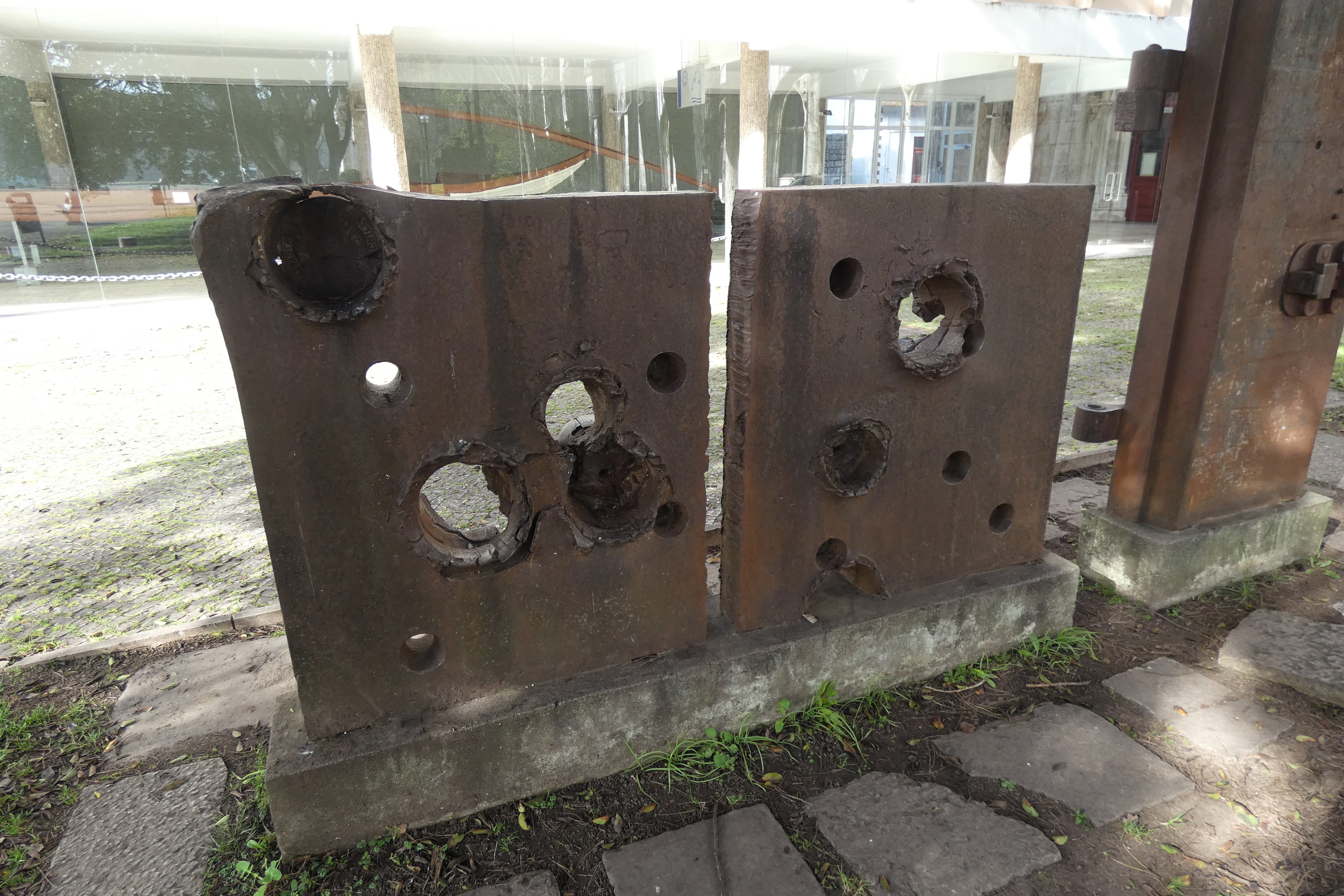
However I noticed this rather interesting display near the museum exit showing a test piece of six-inch armour subjected to penetration tests from some rather large calibre shells if the pieces stuck in it together with the penetration holes were anything to go by.
 |
| Plates used to test the resistance of the six-inch thick armour. |
Of course, this being one of my posts out and about 'on Tour' I was always going to be taking note of the avian wildlife and the picture below is of a bird I can now tick off my 'bucket list' and certainly new to me as we don't get many of these back home.
The Serin, Serinus serinus is a resident bird in the Mediterranean, being a tiny yellow finch, about five-inches in length, with a bright tinkling song that was the first thing that caught my attention.
 |
| The Serin, Serinus serinus, enjoying the sunny weather outside the Lisbon Navy Museum. |
Then my eye was abruptly drawn skyward and into the the canopy above by the sound of Europe's only feral parrot, a call once heard that is instantly recognisable and described as a screaming
keeo-keeo.
 |
| The Rose-ringed or Ringed-neck Parakeet, Psittacula krameri, making themselves known on our leaving the Lisbon Navy Museum. |
The Rose-ringed Parakeet escaped from captivity in 1960's England and as well as being seen regularly by me in the western suburbs of London on trips to visit friends has now migrated to the adjacent Continent frequenting orchards, parks and large gardens.
The Lisbon Navy Museum is an excellent way to better understand the important contribution Portugal has made to maritime history and I thoroughly enjoyed seeing that history through Portuguese eyes rather than the fleeting distorted glance that I received during my British education, that has since broadened with my personal interest in military and naval history and is added to yet more by visits to institutions such as these.
In my final post from Lisbon, before Carolyn and I boarded the train to historic Porto I'll take a look at the Museu do Combatente and the Monument to Overseas Combatants at the Fort of Bom Sucesso.
More anon
JJ


.jpg)

.JPG)


,_after_1834,_Museu_Nacional_Soares_dos_Reis.png)


_RMG_BHC2565.tiff.jpg)
.svg.png)


.jpg)