|
| Roman Carthago-Nova with the harbour are in front and the lagoon at the rear to the north of the city separated by the causeway to Molinete. |
The city of Carthago Nova was captured from the founding Carthaginians and became a Roman city from 209 BC, receiving the rank of Roman Colony or Colonia in 54 BC. This change in status heralded a major change in the city's layout with east-west streets called
decumani and north-south streets called
kardines effectively dividing the city into quadrangular blocks or
insulae.
 |
The Romans capture Cartagena in 209 BC. The map clearly shows the five hills, and particularly the Cero de Molinete,
that form the circumference of Cartagena and the ancient lagoon that occupied the area north of the city.
Courtesy of https://en.wikipedia.org/wiki/Battle_of_Cartagena_(209_BC) |
On these streets stood some of the most important buildings of the Augustan era and first century, such as the theatre and the Augusteum.
I took a look at the, at the time, newly opened Roman theatre way back in 2013.
https://jjwargames.blogspot.com/2013/12/sunshine-good-news-and-cartagena-history.html
During the last ten years or so a lot of archaeology has been going on in the city with more new purpose built display centres springing up amid the modern day city revealing more and more of the Roman and Punic past which, for Ancient enthusiasts, is shedding more light on the ancient history of the city revealed in those finds and so Carolyn and I took some time to explore a couple of the new exhibitions plus a look at two of the major Roman roads recently brought to light between them.
 |
| An illustration of the Molinete area built on the slopes of the hill on the north west corner of the north wall facing the lagoon |
The illustration of Roman Carthago Nova seen above highlights the first part of our expedition which started in the insula of Molinete and the group of buildings revealed there which include a bath house complex together with a series of high status banqueting rooms and houses next to a temple complex, shown in the bottom left corner of the map below.
From there we then made our way to the top of the map to take a look at the Punic Wall section that has been revealed and housed in a display centre designed to protect the archaeology as well as give an impression of the height of the original rampart that defied Scipio and his Roman army.
 |
| A ground plan of the Molinete Insula, bottom left, in relation to the Forum, still uncovered, the Augusteum, bottom right and the Punic Wall on the northern limits of the old ancient city, atop one of Cartagena's five hills. |
There are two other sites that I plan to visit in future trips to the city that include the Augusteum, a temple dedicated to Augustus and a Roman town house but time only permitted these first sites covered here in this post.
 |
| Stepping in through the gates of the entrance transports the visitor immediately from the modern day city to first century Cartagena |
The Molinete complex is part of the archaeological work that has been going on in recent years within the city and the authorities have lavished the site with a purpose built all weather canopy that covers the area and provides a modern viewing layout for the interested visitor.
 |
| The ForoRomano Molinete site has been uncovered and developed within the busy streets of modern day Cartagena seen just over the railings surrounding it and providing an interesting context between the modern, perhaps not so modern, and ancient city. |
The map below reveals the extent of the site with the bath house complex on the left, next to a columned forecourt and next door to this an atrium surrounded with banqueting suites designed for ritual gatherings and with a shrine at the back of the complex dedicated to the gods Isis and Serapis.
Next door, separated by the kardo, or north-south street, is a temple complex consisting of a high walled multi-column portico around a central patio with a small temple at its centre, again thought to have been dedicated to the gods Isis and Serapis, and dating from the mid first century.
The complex of buildings is surrounded by the Roman streets as mentioned in the Roman redevelopment of the city after its raising in status to a Colonia.
 |
| My adapted map illustrating the layout of the Roman buildings uncovered in Molinete now on display to the public, broken down into the four key areas of the bath house, columned forecourt, atrium and banqueting suites and on the right of the kardo, the temple complex. The route of the Kardo (street) indicates north is at the top of the map |
 |
| From left to right, the Bathhouse, Columned Forecourt, Atrium and Banqueting Rooms with shop fronts adjoining the Decumano (east-west street) |
The arrangement of these buildings might be a little hard to grasp just looking at pictures so hopefully the map above showing the different buildings and surrounding street plan should allow a marrying up of the pictures to each section bearing in mind that north is the top of the map and pictures will relate to that.
In addition to the overall map plan I have broken this post up to look at each building complex separately, starting with the bathhouse and working sequentially right to left including a look at the two section of road and street that splits the temple from the banqueting suites and runs along the north wall of the bathhouse.
The banqueting suite of rooms is perhaps the most complex part of the whole site and to help avoid the post just being a bunch of pictures looking at the remains of painted Roman walls, interesting though they are, I have grouped the pictures by room and numbered each room on the map to try and give further context.
 |
If all else fails and you haven't a clue where the pictures are taken from these little map plans
at the head of each section should give you an idea |
As with most Roman sites across the empire, these buildings have often gone through several rebuilds as the use has changed from one century to another or the building has been adapted and converted so I have included many of the excellent sign boards that were dotted around the complex which also help to explain what it is you are looking at and these together with the artists illustrations also posted can help more than words to bring the archaeology to life.
It seems likely that the atrium building at the centre of this complex with its series of banqueting suites formed the core of this group of buildings and is thought possibly to have been established in the first century by a religious corporation worshipping the eastern gods Isis and Serapis with the suites used for holding ritual gatherings whilst worshipping in the adjacent shrine and temple or taking the Roman pleasure of passing time in the nearby baths.
The Bath House (Thermae)
The bathhouse is the first part of the complex the visitor sees on entering and can be viewed from above on a modern day street level platform before descending down to the Roman street and entering the bath house via the next door atrium building and coming into the bath house entrance, at the top of the plan below, with the cold plunge pool on the left and the cold room directly ahead.
 |
| The illustration showing how the baths might have looked in their prime with the north wall to the left of picture and showing the hot bathroom and furnace that lie uncovered under the modern street |
 |
| The bathhouse section of the plan showing the position of the various rooms |
The baths follow the traditional arrangement of moving the bathers from the cold to warm to hot rooms with a sauna and adjoining suites of anointing rooms for applying oils and getting to work with the odd strigil.
 |
| Remains of the hypocaust system beneath the warm room or tepidarium with the caldarium and furnace room still uncovered under the modern street to the left of picture |
In the second century, on leaving the bathhouse happy Romans could partake of a drink and snack in the tavern that occupied the opposite corner of the forecourt that housed its entrance.
 |
| The view of the entrance into the bathhouse from the atrium next door |
 |
| A closer look at the tepidarium hypocaust with flues from the furnaces visible to the right feeding the hot air under the floor |
 |
| Remains of the original marble floor can still be seen in the frigidarium or cold room, The marble, breccia coralina, originates from the quarries of Asia Minor. |
 |
| The cold plunge pool |
 |
| The remains of a seat on the north wall of the caldarium |
 |
| The terraced positioning of the north wall of this building on the side of the hill is illustrated by the first entrance (right of picture) which is a Roman one and the next entrance which is part of a former Spanish Civil War air raid shelter |
The Column Forecourt
As mentioned the forecourt housed the entrance to the bathhouse and its herringbone brick floor,
opius spicatum, surrounded on each side by four colonnades, the northern one comprised columns with Corinthian capitals of Italian marble from
Luna-Carrara, while the rest were Ioanian in style.
Roman bathhouses were as much a meeting place as they were for personal hygiene and relaxation and this one was likely used by the members of the neighbouring banqueting suites.
The brick floor is thought to rule out its use as a
palaestra for exercise and sporting activities, but the later addition of a second century tavern rather underlines the social use for this building.
 |
| The next part of the complex is the ornate first century columned forecourt next door to the bathhouse |
 |
| The colonnade of the atrium with the second century tavern in the top right corner (centre-top of picture). The turning to the left would lead into the bathhouse. |
 |
| The tops of the north colonnade Corinthian columns have parts of the original Italian marble in situ |
 |
| Ionian columns formed the other three colonnades |
 |
| The reconstructed paving of the central space helps illustrate how the original floor, close by, might have looked at the time |
 |
| Abundantia - the goddess of plenty may have once been a feature on the northern colonnade |
 |
| A replica of the horn of plenty discovered here and now housed safely in the archaeological museum |
 |
| The cooking area in the tavern (Popina) at the rear right of the atrium |
 |
| The illustration of the dolphin graffiti, but I couldn't find it! |
 |
| View from the north wall of the atrium with the tavern area directly below. The entrance in from the street can be seen top right lined with columns |
The Atrium and Banqueting Rooms
The atrium building was built in the middle of the first century AD and might have been the meeting place for a religious corporation designed for holding ritual banquets in honour of the gods Isis and Serapis, worshipped in an adjacent shrine.
The whole complex was built in several stages with shops and taverns to the front of it and with the building converted to housing in the third century.
 |
| The two story banqueting rooms, and atrium numbered 1 to 6 situated behind the street shop front |
 |
| View from the modern day street level with the rear of the shops closest to camera and rooms 5 and 3 behind |
 |
| View taken from the same position above looking at the shops rear areas beside the main entrance and rooms 6 and 4, top left |
The Atrium (1)
 |
| The banqueting suite atrium |
 |
| The atrium courtyard with Tuscan columns around a well giving access to four banqueting rooms and a staircase leading to service rooms and a tavern |
 |
| The two holes on the edge of the well would likely have held the arched suspension for the bucket used to draw water for the use in religious ceremonies |
 |
| Remains of the decorative mosaic could still be seen around the well |
The Cult Room (2)
 |
| Part of the decorative wall panel in the Cult Room directly behind the atrium |
Banqueting Room (3)
 |
| The scratched sample of Latin text mentioned in the panel above |
In the third century AD the building changed hands and the interior was divided up into several houses that were still accessed via the atrium.
Room 3 formed part of one dwelling and was found to be fitted with a hearth, working area and cereal mill plus a small store.
At some stage in the fourth century the building was ravaged by fire and the dig revealed the results of the collapse of the building with the unearthing of sixteen fourth century amphorae that had been stacked in one corner and crushed during the collapse.
 |
| The crushed amphorae revealed in the dig in Room (3) |
Some of the contents remained and revealed not only that they contained a mix of wine, oil and salted food but the dating to the fourth century for the destruction of the building.
 |
| Reconstructed amphorae stacked in one corner as they would have been back in the fourth century AD |
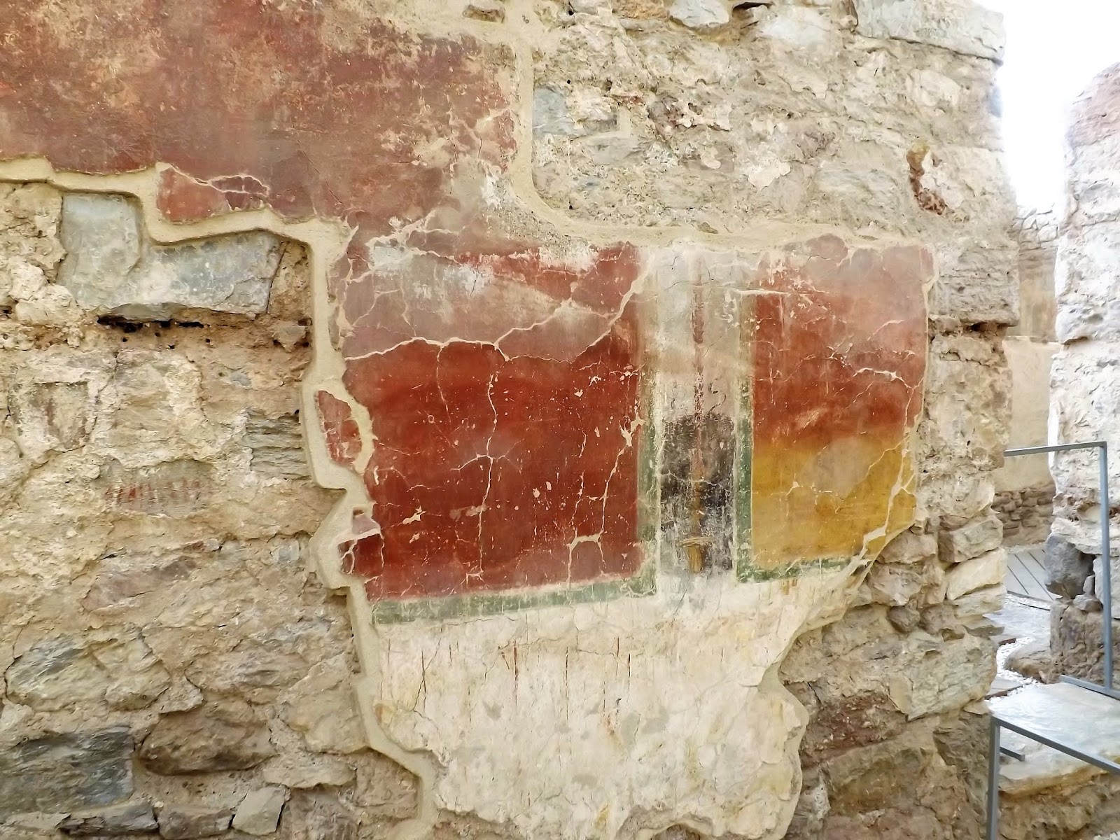
Banqueting Room (4)
 |
| The fantastic geometrically painted panel walls were so very clear from the plaster-work that remained |
 |
| The view from the Roman street and next to the door seen in the illustration above |
Banqueting Room (6)
Banqueting Room (5)
 |
| Drips of paint on the white border of one of the panels from the red paint above looks like they were made recently. These obviously didn't get picked up in the 'snagging report'! |
 |
| These panels and the restored window of crystallised gypsum were absolutely stunning |
 |
| The crystallised gypsum was naturally occurring and highly prized by the Romans as an alternative form of glazing in their buildings producing an ancient form of frosted glass. |
The Kardo and Decumano
I have looked at Roman streets in Britain and in Italy, with Pompeii being one of the most memorable and when looking at the stonework and street furniture one always seems to get a vivid sense of those folk that walked on them in their day to day business so long ago. That feeling was just as strong when looking at these Roman street surrounding these buildings.
 |
| The cart track as mentioned in the panel above |
 |
| The steps on the left of the street are to the doors entering what had been the former banqueting rooms but what were later converted into houses |
 |
| Ah the Romans and their fascination with the male member - apparently a sign of good fortune! |
Southern Spain in particular can be a very dry hot part of the world where a good supply of fresh water becomes very important and the evidence of this can be seen by the numerous water cisterns built by the Romans to capture rain water run off and to store it from contamination.
 |
| This large cistern sits on the corner of the Kardo and Decumano with a guttering leading to it seen in the temple complex next door |
The east-west street or
decumanus was flanked by the north wall of the bathhouse, columned forecourt and banqueting suite with a half roll seen at the foot of these walls designed to avoid water seepage from the street.
As can be seen in the panel below a wastewater sewer runs under the limestone paving and first century roadway has been built over preceding Republican city one as illustrated.
 |
| Looking along the Decumanus with the half roll running along the wall of the building complex seen on the left of picture |
 |
| The whole complex was, as mentioned built on the side of the Cerro del Molinete and this becomes clear when walking along the north wall and seeing the modern day terracing that marks out the incline of the hill today. |
The Temple Complex
In the mid first century AD the temple shrine complex was built on the other side of kardo from the banqueting suites and from the archaeology unearthed reveals a small temple within a courtyard surrounded by a Corinthian columned portico, with worship related rooms situated at the back of it.
The whole area was surrounded with an impressive dressed stone wall that marked it out from other nearby buildings and from the other articles discovered the thinking is that this temple was dedicated to the Greco-Roman gods Isis and Serapis, familiar divinities worshipped in Carthago Nova since the first century BC.
 |
| The base podium clad in white marble and part of the access stairway is all that remains of the temple today |
 |
| The statue of the divinity would have been housed with a roofed chapel supported by a four column facade |
 |
| To the right of the podium can be seen the cover to the two water cisterns that collected rainwater from the roof of the shrine and likely used in purification ceremonies. |
 |
| The remains of the surrounding portico and some of the columns that once fronted it |
 |
| Modern day reconstructed dressed stones recreate the look of the impressive surrounding wall of this temple complex |
As with a lot of ancient Roman buildings and seen here with the change in use of the other buildings seen, the temple complex was not immune to changes in worshipping habits and the needs of the community in the city and with the temple falling into disuse other uses for the area soon found a home.
 |
| What looks like part of the water collection sluice that fed rain water into the large cistern pictured previously |
This completes the first part of our look a ancient Cartagena and in Part Two I will take a look at the main roads discovered in the centre of the old city during development work and now visible to the public together with part of the Punic Wall now housed in a specially constructed display building that protects this amazing structure.
---------------------------------------
Next up Part Two of Roman and Punic Catagena, plus I am getting some coaching on Chain of Command, as a few of us are getting together to play '29 Lets Go' the Omaha campaign, and, following a successful first mission playing the Americans, we are planning the second game for next week, so I will aim to take the camera and share some thoughts about our games and my learning curve!
In addition, I am currently working on the 'Legion of the Dead' with multiple casualties for my Romano-Dacian collection to litter the battlefield with before moving on to complete Warband eight.