

In this second post covering our twenty day driving holiday through Iceland, I pick up from where I left off in the first post having arrived in Reykjavik and our impressions of the city together with some of the history of the first Icelanders related in the collected Sagas and wonderfully captured in the Saga Museum, link below.
 |
| JJ's Wargames - Iceland Land of Fire and Ice |
In this second post I thought I would cover off the impressions of the first half of our circuit around Iceland as we set off from Reykjavik heading out to the Eastern Fjords and our stop over at Egilsstadir (Point 8) and in the next post I will pick up things to the Western Fjords and our stayover at Flókalundur (Point 13) before returning to the capital and home.
Warning: this post, the previous and likely subsequent ones, will likely see me flitting between Icelandic and English place name spellings, unavoidable given that my Icelandic is atrocious, which is, I know, a pathetic excuse, seeing as Icelanders learn English as a second language from age ten, and I operate on the basis of, to quote the Great Bard of Stratford, that '.... a rose by any other name is still a rose' or for my transatlantic cousins, 'you say tomayto, I say tomarto, let's call the whole thing off'.
 |
| Our route plan for our twenty-day drive around Iceland, starting and finishing in Reykjavik as we followed the ring-road, Route 1, and the points on the map indicating where the pictures were taken in my post - roughly. |
 |
| The site of the Althing (Alþing), the annual parliament of Iceland from the year 930 until the last session held at Thingvellir (Þingvellir) in 1798 |
I have to say that Carolyn and I will often do our best to avoid such tourist hotspots with this area renowned, particularly in the summer months for large crowds, often pushing and shoving to see one thing or another, which partly explained our decision to travel in the autumn when crowds are much reduced, that and a desire to experience the Northern Lights without the later extremes of winter weather to contend with.
 |
| The Icelandic parliament building since 1881, seen here next to the Reykjavik cathedral. |
 |
| The rift valley is a geological feature at Thingvellir that displays the meeting point of the North American (left) and Eurasian Plates (right) |
Þingvellir is notable for its unusual tectonic and volcanic environment in a rift valley, that vividly displays the continental drift between the North American and Eurasian Plates that can be clearly seen in the cracks or faults which traverse the region, the largest one, Almannagjá, being a veritable canyon, and it is this environment that also causes the often measurable earthquakes in the area.
 |
| The Execution Trail |
 |
| The Prime Minister's official residence, the Thingvallarbær |
We managed to beat the crowds to Thingvellir and so enjoyed a walk around the site taking in the Execution Trail, where convicted felons would have met their ends in a rather foreboding part of the rift to the Prime Minister's official residence, the Thingvallarbær built for the Althingi millennium celebration in 1930.
 |
| The geothermal area in Haukadalur - I love the smell of sulphur in the morning! |
From Thingvellir we paid a visit to the geothermal area in Haukadalur, which contains the geysers Geysir and Strokkur,, bringing back fond memories of Rotorua although the latter was certainly warmer as regards air temperature.

The third site we planned to include, Point 3, was reserved for the following morning as we had booked a night at the Hotel Gullfoss which is literally just around the corner from the stunningly magnificent Gullfoss waterfall; which after a hearty breakfast we were able to be the second car in the car park and have the place practically to ourselves as we took in this breath-taking wonder of nature.
 |
| The stunningly magnificent Gullfoss waterfall |

Iceland abounds in waterfalls of all types and sizes but I have to say that standing close to Gullfoss on that early morning on our own was one of the standout moments of this trip and we quickly retreated as others started to arrive.

From Gullfoss we headed south towards the coast to pick up the ring road near the town of Selfoss, taking in the volcanic crater at Kerid along the way.
 |
| Kerið volcanic crater |
Kerið or Kerid) is a volcanic crater lake located in the Grímsnes area in south Iceland, and is one of several crater lakes in the area, known as Iceland's Western Volcanic Zone, which includes the Reykjanes peninsula and the Langjökull Glacier, created as the land moved over a localized hotspot, but it is the one that has the most visually recognizable caldera still intact.

The caldera, like the other volcanic rock in the area, is composed of a red (rather than black) volcanic rock, and is approximately 180 feet deep, 560 feet wide, and 890 feet across, being one of the three most recognizable volcanic craters at an age of approximately 6,500 years old.

From Selfoss town we headed along the coast road towards the waterfalls at Seljandsfoss, Point 4, that can be seen from the road cascading like a silver streaks down the black faced cliffs that push out from the higher land towards the coast.

For this little waterfall expedition we needed to don the full waterproof gear over the fleeces and thermals as one cascade offered the chance to follow the path behind it, whilst another entailed threading ones way along the stream running from its plunge pool via a water misted narrow canyon in the cliff.


On the walk back to the car and a change into dryer clothes, we caught sight in the fields beyond the remains of the turf houses of the first folks that settled in this area.
 |
| The remains of a turf walled house can be seen in the field to the right of picture. Later in the trip we would get to sit in a reconstructed early version of one of these that was once the residence of Eric the Red, father to Leif the Lucky but that'll be in Part Three. |
Retracing our drive back along the coast to the town of Hvolsvöllur we found our way to one of the most nicest places to stay during our whole time in the island.


 |
| Carolyn enjoying a relaxing view out towards the sea on the horizon. |
 |
| A magnificent view from my bed in our cabin near Hvolsvöllur, the next morning as we prepared to carry on our journey along the south coast towards the little town of Vik. |
The next leg of our journey saw us heading back past the waterfalls at Seljandsfoss as we drove to the next set of falls at Skógafoss, Point 5, which as well as presenting a series of stunning waterfalls to enjoy also gave us the chance to don the walking boots and head up towards the mountains from where the torrent is developed and to burn off a few calories enjoyed the night before indulging in Icelandic fish stew.
 |
| A rendition of Skógafoss in the Skógar museum depicting visitors from an earlier period of tourism to the island. |
The Skógafoss is one of the biggest waterfalls in the country, with a width of 82 feet and a drop of 200 feet, and due to the amount of spray the waterfall consistently produces, a single or double rainbow which is normally visible on sunny days.
 |
| Skógafoss one of the biggest waterfalls in the country, with a width of 82 feet and a drop of 200 feet |
According to legend, the first Viking settler in the area, Þrasi Þórólfsson, buried a treasure in a cave behind the waterfall, and the legend continues that locals found the chest years later, but were only able to grasp the ring on the side of the chest before it disappeared again.
 |
| Flóki Vilgerðarson was better known as Hrafna-Flóki, seen here encountering Skógafoss in the TV drama Vikings (Season 5) |
The ring was allegedly given to the local church as a door knocker but is now housed carefully in the Skógar museum.


 |
| Carolyn impersonating a Tik Tokker |

 |
| Some examples of turf buildings seen at the Skógar museum |
Working our way back down the path, we stopped at the bottom for a quick bit of lunch and a visit in the Skógar museum before driving further along the coast to our next destination, Vik, but taking a little detour en-route to visit a certain plane-wreck.
 |
| https://amazingiceland.is/destination/the-story-of-dc3-or-c-117-plan-wreck-on-solheimasandur/ |
I say a certain plane-wreck because the one we had intended to walk to, a US DC-117R4D that crash landed near to Sólheimasandur beach on the 21st November 1973, has become a tourist hot-spot, gradually damaged with graffiti, with people clambering all over the historic wreck, the site sadly made more famous by a certain Justin Bieber in a short video clip of him and it which has made it an even more of a must-go destination for certain folks.

So instead we headed for Eyvindarholt just along from Skogafoss and an older wreck of a wartime US DC-47J that was badly damaged during a taxiing accident resulting in a broken undercarriage and wing damage that saw the aircraft written off.
 |
| The former US Navy Aircraft C-47J, No. 150187, at its final resting place at Eyvindarholt after a crash on landing at Saudanes airstrip, 25th July 1969 |


Navy Aircraft No. 150187, built in 1944, took off from Keflavik on the morning of the 25th July 1969 on a support flight to the Navy Communications Station at Mount Heidarfjall near Thorshofn in northeast Iceland, and a landing at Saudanes airstrip.
 |
| C-47J No. 150187 flight from Keflavik on the morning of the 25th July 1969 on a support flight to the Navy Communications Station at Mount Heidarfjall near Thorshofn in northeast Iceland, and a landing at Saudanes airstrip, with her final resting place at Eyvindarholt shown. |
The pictures below capture the moments of the fateful landing at Saudanes with the windvane in the picture on the left clearly showing the aircraft with a tailwind, not exactly ideal, with a preference to landing into wind to maintain lift at a lower speed for landing and the runway running roughly east-west.

On final approach, the wind shifted to north-north-east blowing on the aft quarter of the aircraft, but still the landing was normal, however as the speed dropped the crosswind effect on the tailplane caused the aircraft to veer to the right, and since the tail wheel had not yet been locked in a straight position, it caused the aircraft to run off the right side of the airstrip, where the right hand landing gear hit a pile of driftwood and the left landed in a depression and gave way, causing the wing tip to hit the ground.

There were no injuries to the passengers or crew, but the aircraft was deemed too badly damaged to be repaired, with useable parts recovered, and the wreck sold off.


Continuing our drive along the coast we arrived at our next stop for the night at the lovely little coastal town of Vik, lying between the coastal lava flows of the mighty Katla volcano in the mountain range behind it; and we experienced the astonishing way weather conditions can change from one part of the island to another, finding as we crossed over some very high ground to descend into the town sudden very high winds hitting the car and on walking to our lodgings almost making it impossible to walk in a straight line.
 |
| The town of Vik seen from the beach the next day, with its delightful church perched on the high ground designated the place to retreat to should Katla, the glacier seen peeking through the gap in the mountains, erupt and cause a tsunami. What fun and how we laughed! |
The next morning, suitably refreshed and fed, Carolyn and I walked the beach path at Vik that winds its way through the marram grass that now covers the land created in 1918 by Katla's last eruption and provides a natural sea defence to the fierce seas encountered off the black sand beach that has been a danger to both tourist and fisherman careless to ignore the treacherous waves that can easily drag the unwary from the shore into a rip current that will carry the unfortunate out to sea, paralysed by cold and death by drowning in minutes.
 |
| The sculpture entitled 'Voyage' overlooking the beach at Vik |
The sculpture seen above is entitled 'Voyage' and has a sister sculpture in Hull, UK, and both were created to symbolise, in 2006, thirty years after the ending of the last of the Cod Wars, touched on in my post about Reykjavik, the bond between the UK and Iceland with more than a thousand years of sea trading between Hull and Iceland; and specifically to fisherman and other seafarers who, over the centuries, have braved the perils of the sea, and as a memorial to those whose lives have been claimed by the hostile waters of the North Atlantic.

Steinunn Thorarinsdottir was commissioned to create the sculpture and both figures face out to sea to emphasise the waters dividing our islands are also trade routes that unite them.


The coasts of south-east Iceland are commonly called Europe's ship graveyard as over one-hundred ships stranded there in the twentieth century and it is impossible to know how many ships are lying at the bottom of the ocean along the coast.
 |
| As this map of Vik beach portrays, this stretch of black sand is a ship's graveyard all in its own right. |
Sometimes the crew managed to be rescued and if the cargo was accessible, locals would call it a good shipwreck. Understandably so, as the cargo was often quality goods such as wine, coffee and building materials, true treasures to Icelandic farmers at the time.

In the late nineteenth century, cold winters and hardships forced the men of Vik to take up fishing again, despite the difficult sailing conditions. The ocean provided an abundance of fish but there came long periods where the sea was too rough for the six-or-eight-oared rowing boats.

From Vik we backtracked slightly along the coast to take a look at another more infamously dangerous beach than the one at Vik and one that sadly proves that often stupid is what stupid does.
Reynisfjara beach is without a doubt the most famous beach in all of Iceland, and you’ll see it featured on postcards and brochures throughout the country, as well as on pretty much any travel blog or video about Iceland; and what sets Reynisfjara apart from all the rest are its black volcanic sands, smooth pebbles, unique rock formations, overall moody atmosphere and huge waves crashing on the shore.

Even when the sea was calm, the waves by the shore made fishing a difficult and dangerous task and the crashing waves took many lives, with the last disaster occurring in 1941, when six men lost their lives and only the captain survived.
 |
| The wind had whipped up rough seas off Vik beach the day we walked it. |
 |
| The Gardar cliff surrounded by Tik Tokkers and thrill seekers at the water's edge |
 |
| The signs warning of the hazards couldn't have been clearer with clear guidance about how far to stay back from the sea, seemingly ignored by many when we visited. |
Did I mention huge waves crashing on the shore, because there sure are a lot of very impactful signs warning about this hazard and what not to do to avoid dying horribly but it seems to no avail, with the last fatality occurring in 2022, the fifth of its kind in seven years, when a man in his 70s went into the sea despite the dangers and was killed.

Sneaker waves (also known as sleeper, king, or rouge waves) are huge coastal waves that can suddenly appear in a train of smaller waves. The sneaker waves are much larger than those in between and reach way further. The time between the giant waves can vary, sometimes, one comes right after the other, or there can be up to tens of smaller waves in between. The waves can rise very fast just before hitting the shore. This happens because the ocean floor deepens rapidly away from the coast. In addition, the ocean currents are very powerful and add to the danger.

The Gardar cliff, which is composed of dark basalt columns that some say resemble a pyramid or organ pipes, brought back memories of Hallgrímskirkja church in Reykjavik, and further along the beach we had a spectacular view of the arched cliff of Dyrhólaey looming over the sea.
 |
| The arched cliff of Dyrhólaey could be seen at the other end of Reynisfjara beach |
When an ocean wave grabs you, you are knocked off your feet and it is very tough to stand up and find balance again. One of the reasons for that is that the wave creates a suction that drags you out and washes the sand and gravel from under your feet. Once you are in the water, the currents will pull you away from the coast and nothing can be done to save you. The water is also freezing and you suffer from hypothermia within just a few minutes.

I have to admit a slight feeling of relief as we finally got back on the road and were well to the east of Vik, as only the previous month the bridges carrying the ring road just east of the town were washed away in a massive rush of flood water from the Katla glacier, thought to have been caused by the heating up of the volcano beneath, that caused the lower ice to melt and send a torrent of flood water and rocks down its historical run-offs that destroyed the road bridges.

The Icelandic authorities had the bridges rapidly replaced within a few days, which illustrates the importance of the one main highway in the island and had it been out of service during our tour it would have dramatically messed up our travel plans to proceed anti-clockwise around Iceland, with all our accommodation arranged to that plan.

From Reynisfjara beach we continued our journey eastward towards our next stop at the curiously named 'The Potato Storage', Point 6, enjoying some spectacular terrain viewed along our route as we went.

We developed an expression when driving in New Zealand as suffering from 'wow fatigue' as we continually turned another corner of the road ahead only to be confronted with yet another 'wow moment' and the southern coast road of Iceland was up there for that.


The lava fields were also variable with examples of what I think were pillow lava, seen above, covered in mosses, formed possibly when this area was still under the sea, explaining the rounded pillow shaped clusters of rock running either side of the road.
Whilst around a corner in the road the lava field would change to the more usual broken rocky terrain more likely formed when upper deposits of new lava were laid on already established rock layers creating the Martian vista seen below.


 |
| 'The Potato Storage', Point 6, a simply glorious part of Iceland to base ourselves in for a couple of nights and our landlady kindly kept us up to date with timely text messages informing us of likely night time sky activity. |
 |
| The mountain behind our chalet would form the perfect backdrop to the night time show that would come with the dark skies. |
That night the skies were particularly cloud free and the temperature drop as the sun went down reflected that fact, and at about nine-pm we were treated to an amazing display of the northern lights (aurora borealis), which appeared as a slightly milky green ribbon crossing the night sky with stars blinking behind the haze effect it caused, but when captured by the camera on night time setting revealed its extraordinary beauty.
 |
| The northern lights (aurora borealis), photographed the first night during our stay at 'The Potato Storage'. |
Needless to say with such an extraordinary night light show we were soon joined by neighbours in next door chalets, clad in night-time attire with coats woolly hats and gloves over the top to keep out the cold.

However the scientific explanation doesn't do justice to this amazing phenomena and I should add that the pictures are far more glorious than the view experienced with the naked eye, which meant an excited moment of expectation as the gallery button was pressed on the phone to reveal what had been captured in the previous shot.

Following our night-time entertainment we were off the next morning to join Troll Expeditions for an adventure on one of the nearby glaciers as we prepared to don helmets and crampons to join our guide getting up close and personal with the ice.

This was a very interesting experience and it was very noticeable how quickly the air temperature cooled as we climbed higher to get on the lower slopes of the glacier where we had a briefing on the history of this particular ice formation together with an introduction to the niceties of using crampons and avoiding going a-over-t in a very ungainly fashion, which I'm pleased to report all our party managed.
 |
| Oh dear, a case of 'all the gear, no idea', and I off course only include myself in that declaration. |


 |
| The Route 1 road bridge over the river mouth of the Jökulsárlón Glacier Lagoon |
 |
| The lake side view of the road bridge looking towards the sea, with Diamond beach to the right side of the river mouth. |
The lake has grown since then at varying rates because of melting of the glaciers, and the glacial front is now about 5.0 miles away from the ocean's edge with the lake covering an area of about 6.9 square miles; and 2009 it was reported to be the deepest lake in Iceland, at over 932 feet, with glacial retreat extending its boundaries to see the size of the lake has increase fourfold since the 1970s.
 |
| The Jökulsárlón Glacier lake covering an area of about 6.9 square miles, with the glacier in the right background. |
We decided to get a closer look at the lake and glacier so ended up donning immersion suits and life vests before boarding a rib, one of two such boats, to enjoy, if that's the right word, a rather bumpy ride out to the glacier, stopping occasionally to take a look at the astonishing ice bergs that had broken off and begun their journey to the sea, with the smaller bits ending up on Diamond Beach.

 |
| Icebergs are truly awesome sites especially when you recall that this is only one third of the thing, the rest lurking under the surface. |

 |
| Enjoying the balmy Icelandic sunny weather in front of the Breiðamerkurjökull glacier |


It's rather fascinating to think, as one admires the ice sculptures sitting on this beach and the smaller crystal clear chunks dotted about, that much of this ice is thousands of years old, trapped previously in the glacier that created them and ever so slowly making their way to the sea, and the glass like, or should I say diamond like clarity of them is remarkable.

 |
| Carolyn managed to find the perfect rock, complete with a ring finger hole. Thankfully I was never required to buy a rock quite that size! |
Our road trip continued after all that ice with our drive to our next stop-over and a rather special place to visit as it turned out.

The Viking village at Vestrahorn, Point 7, set against the black sand beach of Stokknes was a film set for a movie that was never filmed, with most of the materials used when building the village being driftwood collected from the beach and old telephone posts.
 |
| Close by is a NATO radar base highlighting the remoteness of this piece of coastline |

The Viking Village film set is located on a local farmer’s property in southeastern Iceland, near the charming fishing towns of Hofn and Hornafjordur, and built in 2009, the village is a replica of an authentic Viking village, created as a movie set for a Universal Studios production. However, the show scrapped it as a filming location for budgetary reasons, and since then, the area has been open for curious visitors to explore at their leisure.

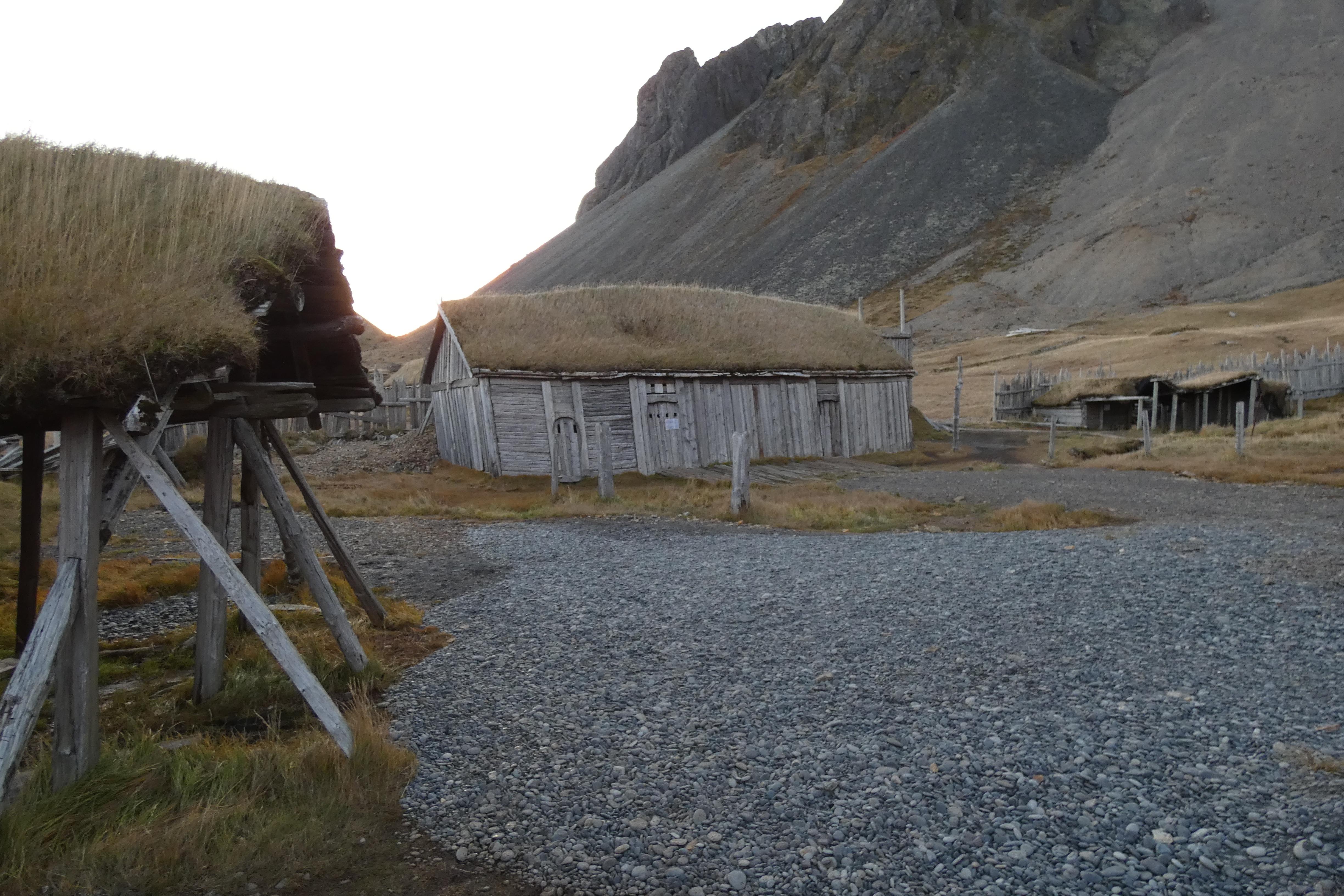
In 2018, the same movie company acquired the rights to produce Vikings, a movie about early Vikings and Icelandic adventures, and the film used the village as one of its sets; and more recently, Netflix used the site for their series, The Witcher, in filming the show’s prequel, Blood Origins, but enough said about that rather sad debacle. Finally in 2022 a Viking ship was added to the lake nearby.


When we arrived, we quickly checked in to our chalet and then set off to walk along the beach path to see the village and get a feel for the location which was only enhanced with the evening light as the sun started to dip lower in the sky creating an even more evocative feel to the place.


 |
| Hvalnes Lighthouse |
Built in 1954, and put into operation the following year, the bright orange Hvalnes Lighthouse, above, stands 38 feet high along the ocean coast and marks a prominent cape, the Austerhorn, on the southeastern corner of the country.
Algerian buccaneers actually landed here in 1627, robbed and plundered, but could not find any people, because everyone was busy working in the summer pastures.
Djúpivogur is home to Langabúð, one of Iceland's oldest commercial buildings, with the south end dating back to 1790, but the building only took on its present appearance when the northern part was constructed in 1850.

 |
| The little town of Djúpivogur of 600 souls where we enjoyed a morning hot chocolate in the Langabúð museum café |
Langabúð served many purposes, being a warehouse and slaughterhouse, and today, it is home to a café, the heritage museum and an exhibition on the Icelandic sculptor Ríkarður Jónsson, who was native to the village.
 |
| The Langabúð museum café in Djúpivogur, the red building to the left, was originally a former log warehouse dating from 1790 and served up a very welcome thick hot chocolate. |
Reyðarfjörður lies at the bottom of the fjord that lends its name to the town which is the largest on the east coast of Iceland, and like most other towns in the East Fjords, it is surrounded by mountains, of which the highest is about 3,189 feet high.
 |
| Reyðarfjörður church, another of the fjord towns passed through on our drive to Egilsstadir |
Reyðarfjörður was a trading port, as well as a fishing port, and due to its strategic location and good harbour conditions, became the second-largest of the Allied bases in Iceland during World War II.
Stöðvarfjörður seen below is recorded as having been settled by Þórhaddur 'The Old' from Trondheim, Norway, and archaeological investigation of the site at the farm Stöð in Stöðvarfjörður has revealed two Viking-age longhouses, the older of which was built shortly after the year 800, and it is thought that the settlement was a seasonal camp for fishing and hunting, rather than a permanent settlement.


In the next post I'll pick up our time exploring the country around Egilsstadir as we prepare to head off into the snowy wastes of northern Iceland as the weather starts to close in on our journey back towards Reykjavik.
 |
| The town of Stöðvarfjörður on the northern shore of the fjord that gives it its name |
As we climbed over the odd mountain ridge, we started to encounter the first snowy weather as we got closer to Egilsstadir and the next few days would start to get more interesting with regards to our travel plans as we had to check the Icelandic travel app each day to find out if roads we planned to use were likely to be challenging or even passable, with decisions to be made on alternative destinations and routes should the weather make things difficult, but as a wargamer one is used to the plan changing on first contact with the enemy and a flexible plan was maintained throughout our journey.


Finally as we descended into the valley in which Egilsstadir is nestled in, our home for the next couple of nights hove into view across the other side of the river known as Lagarfljót, a long body of water some 16 miles long and up to 367 feet deep in places, and like Loch Ness, rumoured by locals to have a serpent, called Lagarfljótsormurinn, living in its depths.
 |
| Our accommodation, centre of picture, seen across the Lagarfljót in Egilsstadir which would be our base during our two day stay in the Eastern Fjords. |


 |
| On the lookout for Lagarfljótsormurinn from the deck of our chalet at Egilsstadir |
In the next post I'll pick up our time exploring the country around Egilsstadir as we prepare to head off into the snowy wastes of northern Iceland as the weather starts to close in on our journey back towards Reykjavik.
More anon
JJ
No comments:
Post a Comment