

Following on from my first post looking at Roman and Punic Cartagena and specifically the ForumRomana Molinete first century AD complex of buildings our visit shifted to a much earlier part of the city and its establishment as a Carthaginian one rather than Roman.
CarthagoNova/Cartagena - Punic & Roman Cartagena Part One
"It is by far the strongest of all cities of this region. It has a privileged position, a well built wall and it is provided of ports, a lagoon and silver mines. Here and in the surroundings there are many factories making salted products. It's the main trading centre of these goods from the interior. They have been changed for the others coming by sea and these for those coming from the interior."
(Estrabon, Geografia, III, 4, 6) end 1st century BC
After their defeat in the First Punic War and faced with the challenge of meeting Rome's punitive post war conditions for peace, the Carthaginians focused on an ambitious plan to rebuild their reduced empire by an expansion into Iberia, following a long tradition of Phoenician trade on the south coast with towns such as Gades and Malaka; that predicted an interior rich in precious metals, particularly silver and other important trade items such as lead, salted fish and esparto (a fibrous grass common in southern Europe used for basket weaving, cords and ropes, particularly useful for rigging out ships).
The map below outlines the three phases of this, at first, political invasion led by the Barca family, and Amilca Barca in particular using their network of connections to facilitate control of key towns along the coast by alliances with tribal groups seeing their control leapfrog along the coast via the valley of the River Guadalaquivir and the gradual establishment of Punic armies in the wake of this advance, a process that ended somewhere around 220 BC.

The second phase, led by Asdrubal, sees the alliances established, formally developed into diplomatic relationships with the Punic takeover of the tribal capital of Mastia, renamed Quart-Hadast, gaining control of a large territory providing trade items in sufficient quantity to enable the raising and maintenance of his mercenary army. The new city assumes the role of Punic capital in the Iberian Peninsula similar to its North African equivalent, Carthage.
This second expansion inevitably raised tensions with Rome and her Greek allies in the region which were managed with treaties agreed to limit Punic expansion up to the River Ebro.
Following this foothold being established, the Barca family, finally lead by Hannibal, would lead expeditions further into the heart of the interior and eventually spearhead the war against Rome in the Second Punic War that would see Hanibal's invasion of Italy via Sagunto and the Italian Alps, followed by a Roman counter-invasion of Punic holdings in Iberia and the eventual fall of Quart-Hadast (Carthago-Nova) itself in 209 BC.

As with other major cities of the ancient world from this period, Carthago-Nova was encompassed by a city wall and Punic city walls seem to demonstrate some common design characteristics that have been revealed with the uncovering of a section of the original Punic wall around Cartagena.
 |
| The galleried walls of Thapsus in Sicily a design incorporated into the walls of Carthage and Carthago-Nova |
The walls are thought to date from 225 to 220 BC and the illustration below shows the construction process with the foundations established for the parallel walls and the positioning of the dressed stone blocks supporting a double floor galleried wall to a height of ten metres, about thirty-three feet in real money, crowned by a patrol platform and crenellated wall.

The gallery design of this style of wall is clearly shown by the top down view of the revealed section in the purpose built hall protecting the revealed wall.


The building that surrounds the revealed wall is a marvellous design in that it allows a descent from the modern day ground level to the Punic wall through a series of stairs that mimic the layout of the original wall interior and in addition the visitor can ascend to the roof of the building that mimics the height of the original wall and gives a view out over the modern day city of Cartagena.
As you can see the wall itself can be viewed close up and a real impression of its construction gained from seeing the different stonework and building techniques used on the exterior and interior parts.


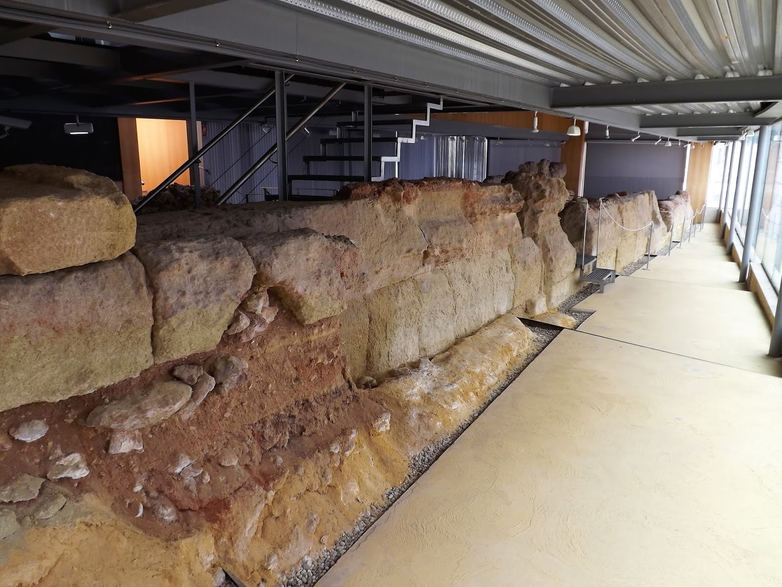

It is quite something to remember when walking around this stonework that this is the remains of the section of wall that Scipio's Roman assault infantry clambered over in their surprise attack that led to the downfall of this Punic stronghold.


 |
| Dressed stone blocks seen here front the outer wall |
An interesting though completely separate part of the gallery is the preserved remains (quite literally) of the funeral crypt of the San Jose Hermitage standing adjacent to the Punic wall and whose precise date of construction is uncertain but is known to have been in use in the middle of the sixteenth century with the crypt being the last resting place of the brothers and priests living there.

Built over and almost into the remains of the Punic Wall, the Hermitage fell into disuse and abandonment in the nineteenth century following its damage in an earthquake in 1829 and the below ground crypt was unearthed alongside the excavations of the ancient wall.


As mentioned in the first post, Carthago-Nova went through a transformation in its urban layout following the Roman occupation of the city and its raising to the status of Colonia in 54 BC most clearly demonstrated by the new roads and streets created around the two central main roads that crossed the city.

The two sections of this road network seen in the pictures below show a secondary Kardo (north-south street) over-built by the modern-day Bolulevard Jose Nieto dated to the time of Augustus which crossed the main road into the city or Decumano Via Augustus running east-west across it.

The majesty of the great central road into the city, the Via Augusta, is emphasised by the never ending Roman road leading to all parts within the wider empire in the picture below, placed at the end of the revealed section pointing in the direction of the east gate.

The roads passage through the city can be gauged from the map below showing its eventual departure from the city via the west gate above the Molinete Hill (top left) and over the causeway between the harbour and the lagoon to the north of the city.
 |
| The Via Augustus is marked on this map travelling east west across the city with the lagoon to the top of the map (north) and the harbour to the bottom (south). Other major buildings in black are indicted withing the city limits such as the theatre, bottom left and amphitheatre, bottom right. Note also the five hills within the city limits. |
One-hundred and ninety feet of road have been revealed and the width of it varies between fourteen to twenty feet.

It is paved with large grey slabs of limestone laid on a bed of rammed earth, under which a channel has been laid in the centre to capture rain and waste water from the houses that would have stood along it on either side, with the channel leading into the main city sewer.

On each side there are large stone slabs laid delineating the pavement for pedestrians and clearly marking the limit of the roadway.

The eastern side of the city was gradually abandoned through the second century AD later to be reoccupied in the late Roman-Byzantine era with the establishment of a necropolis outside of, as tradition dictated, the populated area of the city.

Below is the smaller Kardo that runs across the Via Augusta at this point and reveals a similar if narrower layout to the main road.


I hope you have found these two posts looking at the Romano-Punic history of Cartagena interesting and I hope to cover off some more interesting historical parts of the city in future posts.
Very interesting!
ReplyDeleteI love these posts- very inspiring for those of us that like to build war games terrain.
ReplyDeleteVery interesting and very nicely illustrated, excellent post!
ReplyDeleteNice read with some very good pictures to get an idea of the subject matter.
ReplyDelete