
 |
| Carolyn standing in the amazing Neolithic/Bronze Age Hingston Hill stone circle at Down Tor Stone Row |
With restrictions on movement in the UK gradually relaxing with all the possible implications that might have in terms of the control of the pandemic, the opportunity to explore the countryside to get a bit of physical exercise away from home is opening up and Carolyn and I took advantage of the new rules to take a trip out to Dartmoor to walk and visit some of its many neolithic monuments, many of which we have not seen before.
 |
| The map shows Burrator Reservoir and where we walked on our recent visit to Dartmoor |
The area we went to is close to Burrator Reservoir, a large lake built above Plymouth in the centre of a series of connecting valleys, or combes as we call them in Devon, in the late 19th century to provide fresh water for the city and near abouts.
Dartmoor National Park is a natural moorland upland slap bang in the middle of Devon, created during the ice age which left this granite based moor covered in rocky outcrops or tors and amazingly balanced stones left on top of them when the ice receded.
This ancient landscape is covered with neolithic, bronze age and iron age settlements and monuments which reminds the visitor of the distant history of the land with its many ruins in the landscape, so beloved of Tolkein in his Middle Earth fantasy which is so easy to imagine in this part of the world.
 |
| The OS walking map with Down Tor at the centre of our planned route to Cuckoo Rock and Down Tor Stone Row |
I had discovered several recommended walks in the area, but decided to opt for a relatively short jaunt, just 3.5 miles, although the walk would feel more than that with a lot of off road and track hiking and up-hill, down-dale effort to get around the central key feature of Down Tor at one end of the reservoir, with several hut circles and settlements near to and on the way to the stone row itself.
The other reason for my choice was to use my ViewRanger app on the phone for which I had downloaded the OS 1:25000 Explorer Map of Dartmoor and on which I had plotted our walk the night before and which would allow me an opportunity to try it out in this way.
 |
| My ViewRanger route planned in on my phone shows up in blue with my route recorded in red on the digital version of the OS map seen above |
I have used this app in Spain last year for our Peninsular War battlefield tour and the previous year walking Offas Dyke with Mr Steve, but hadn't yet tried it with a pre-set route that I had plotted to follow.
Back in the day, I used to use a compass and paper map, but in these days of sat-nav and the ability to carry all the information on your phone I am very happy to embrace the technology to help in planning longer and more interesting excursions
 |
| If you look closely you can see that Carolyn and I took a few detours on the way to look at stuff and we ended up walking the route the other way than I had planned, as I set out on the wrong bridle path but carried on once I had discovered the error to see how practical making changes was with the device. No problem at all! |
The first part of the walk had us following an old bridle path up from the car park and soon brought us to our first ancient buildings, namely the remains of the medieval Middleworth Farm with the old farmhouse looking rather forlorn covered in a velvet of local mosses and lichens.
 |
| The path leading up from the car park to Middleworth Farm |


As we followed the valley of the Narrator Brook to our right, on our left the lower slopes of Down Tor presented indicating we were leaving the lower ground around the reservoir and climbing up on to the higher ground of the moorland above.
 |
| Down Tor peaks out above our path as we moved along from Middleworth Farm to the neighbouring ruin of Combeshead Farm next to a gloriously old oak tree |
 |
| The old oak on the boundary of Combshead Farm a bit further along the path |
The ruins of Combeshead Farm indicated a larger range of buildings than its neighbour along the way, but no less robbed out of its valuable stonework.


On leaving the ruins of the farm we were immediately struck by trees draped as they were in a wispy lichen that hung down from their branches as well as lacy looking clumps that adorned the lower branches.
 |
| The wispy lichen hanging off the trees here was most noticeable and very unusual. |


The trail climbed steadily and soon enough, Cuckoo Rock, a curiously shaped piece of granite on the highest point cut into it by two large horizontal gashes, not doubt carved out by wind rain and ice over the centuries, hove into view, with the ground before it covered in ferns and bushes.
 |
| Cuckoo Rock a very noticeable landmark on our route as we climbed ever higher |
On the climb up, the path became overgrown in ferns amid which we met some of the local residents, Dartmoor ponies, that wander free on the moor and together with their Welsh counterparts are reminders of the Celtic ponies that puled the chariots and provided the mounted arm of the Britons who faced off against Caesar's and Claudius's legions.
 |
| A mare and foal, Dartmoor ponies forage amid the ferns and proved difficult to spot until you were really close up. You have to be cautious when the foals are about as mums can be rather protective. |
 |
| Dartmoor is high up and exposed to the worst of the weather in the South West and the granite bears testament to the harsh effects of the climate, particularly in the winter. |
 |
| Getting near to the top now! |
 |
| Well if we get stuck up here at least we some slight shelter - me first! |
The view from Cuckoo Rock from the way we came and our climb up to it to the the view out to Combshead Tor on our next part of the walk were truly stunning and made a perfect stop point to grab a drink and a quick snack before pressing on.
 |
| The view of our path up to Cuckoo Rock with the ruins of the two medieval farms nestled down in the trees to the extreme right and the valley of the Narrator Brook following the trees in the valley left to right. |
 |
| Now on top of the high ground behind Cuckoo Rock we could see the back of Combshead Tor and beyond that Down Tor stone row. |
 |
| Another Tolkienien reference, perhaps Eleanor? The moor was dotted yellow at this time of year |
I really enjoy the challenge of finding my way around in open country and identifying specific landmarks to navigate by, ever since I got lost learning to fly years ago on my pilots qualifying flight but went back to the basics of narrowing down my exact position based on known landmarks, to get back on track and pass my test.
Here I was just trying to find the stone row and found myself scanning the horizon from Combshead Tor and suddenly realise I had been looking at it for several minutes before it dawned on me exactly what I was looking at.
 |
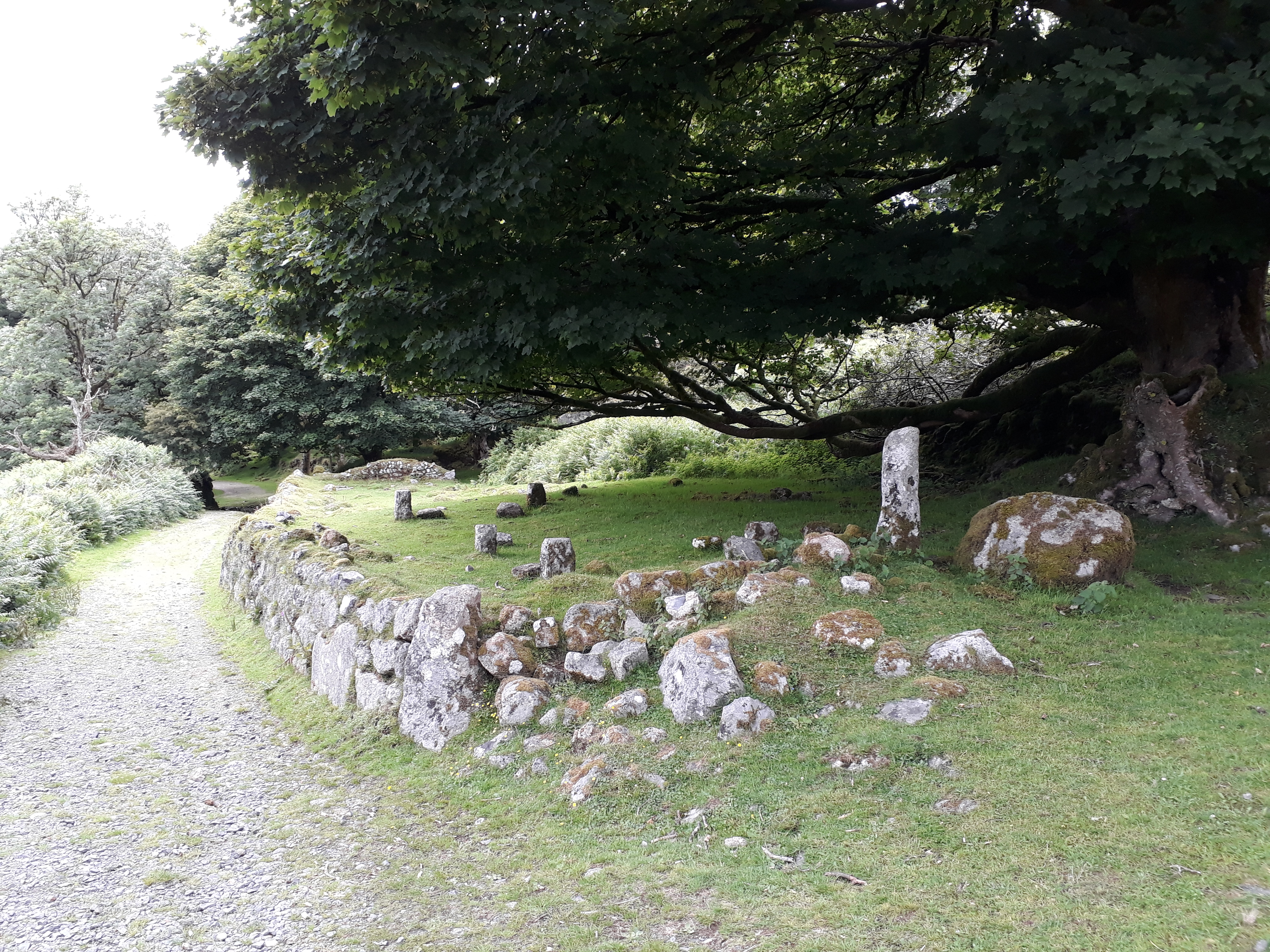
| The neolithic monument that is the stone row and cairn or collasped burial mound within the stone circle at one end, known as Hingston Hill Stone Circle |
Its really amazing to think that this burial mound and stone monument was constructed somewhere between 4000 to 2500 BC possibly just into the bronze age and represents the work of some of the most ancient inhabitants of the British Isles, with the landscape very much as it would have been then.


 |
| Carolyn follows the path back in time |
With the highlight of our walk found we headed back up hill to start the descent back down to Burrator Reservoir and the car park, with Down Tor ahead and to the right of our path but with a significant enclosed settlement to look at on our way down.
 |
| Our path back to the car with Down Tor to the right and Burrator Reservoir in the distance. |
 |
| This curious Ice Age landscape left boulders precariously perched on rock ledges |
The high ground here is covered in granite boulders and made identifying the boundary of the enclosed settlement difficult at ground level.
 |
| The circular shape of these piled rocks indicate the circular boundary of this early settlement, perhaps where the people who built the stone row came from |
 |
| The remains of a round house within the settlement can be seen peaking above the ferns in the centre of the picture, within the enclosure |
 |
| Two gnarled trees seemed to mark the route between them down to the car |
 |
| As we descended the path opened out, but the clouds still threatened rain |
With the settlement identified we pressed on down the slope, enjoying the copious amounts of fresh air and grateful for the threatening clouds holding off from unloading a shower before we were back to the car.
Dartmoor is a fantastic place to walk with lots of interesting places to visit and we had a great time exploring around Down Tor, which made such a nice excursion after our several weeks of lock down.
I am looking forward to getting back into more walking in the year and will share the adventures here on JJ's
For more information on the sites visited I have attached the following links:
Next up, the crowds line the wharf to see the mighty 112-gun Santa Anna join the Spanish Squadron
An immense vicarious pleasure to follow along on your ramble: thanks for posting this. I am amazed that there isn't another person in sight in those broad vistas and panoramas--I can only imagine how that must have enhanced the atmosphere.
ReplyDeleteHi Ed M,
DeleteThank you, glad you enjoyed the read. There were a few folks about, but the moor is a big place and you can always find corners of it that are empty of people leaving you to just enjoy the scenery and wildlife.
Cheers
JJ
What great way to spend a summer day. I've never been to Dartmoor but it reminds me of Beacon Beacons - a cold and wet memory from my misspent youth. Cheers Greg
ReplyDeleteHi Greg,
DeleteYes indeed, we walked around the reservoir the previous week and it was very sunny, hot and quite busy.
Very similar country to Brecon and a favourite training area for the Royal Marines and before them, the US 29th and 4th Infantry Divisions on their warming up for D-Day, although I don't think it helped much when they found themselves amid the hedgerows on the Contentin in Normandy.
JJ
An excellent report.I must confess my jealousy of you living so close to such ancient monuments. Nothing in my hemisphere come anywhere close.
ReplyDeleteHi Anton,
DeleteThank you and glad you enjoyed seeing our little excursion.
Well I see you hail from La Belle France and I have spent many a glorious day in Normandy, Gascony, Bordeaux and Champagne, exploring battlefields and castles a plenty, some of which are recorded here on the blog.
I also had lots of fun exploring Paris on two occasions, that I covered here on the blog, not exactly Dartmoor but just as special in its own way.
JJ