
 |
| Artists impression of the tribal capital of the Silures and Veterans town of Venta Siluram modern day Caerwent as it may have looked in the mid-fourth century and pictured from the east gate. |
This final post is the third one in a series covering a walk Mr Steve and I did back in sunny September this year which looked at the three marcher castles, White Skenfrith and Grosmont and the surrounding welsh boderlands, Raglan Castle and finally Caerwent, the market town of the Silures established in the 1st century AD.
If you would like to pick up the post covering parts one and two you can follow the links below:
Additionally this post handily follows on from a two part post looking at Carolyn's and my visit to Caerleon and the base of II Legion Augusta, together with our visit to the National Roman Legion Museum back in 2016.
Likewise the links covering that visit can be found below:
Ever since that visit back in 2016 I had been looking forward to walking around Caerwent, especially when Mr Steve sent me some pictures of the excellently preserved town wall he took during a previous visit.
That said I was still awe struck seeing the archaeology myself and I hope this post will do justice to what must be one of the best preserved town walls in the UK, if not in the former Empire, and encompassing a modern day village situated among the ruins of the former Roman one, with life continuing much as it did nearly two-thousand years previously.


As looked at in my previous post looking at Caerleon and the establishment of the Legionary fortress, this part of what is now South Wales saw a bitter struggle between the Roman invaders and the Silures, the local tribal group, who over a thirty year period put up stubborn resistance to the Roman presence inflicting stinging defeats on their forces and causing Emperor Vespasian to focus increasing efforts to finally put down the resistance and impose control.
Caerleon, like Chester and York would become a permanent base for one of the three Legions garrisoning the island providing vexhilations from II Augusta to patrol in the north of the island as well as on the continent but acting as the Legion's centre of operations and a base to oversee the occupation of a formerly troublesome part of Britannia.
As with other Roman bases, veteran legionaries often chose to settle in the area in which they served and in doing so added to the process of 'Romanisation' by entering into local civilian life often with a family started during their military service and with a significant pension to allow them to set themselves up as leaders within that population as well as providing a source of experienced military manpower should emergency require.
However, as we shall see at the conclusion to this post, Venta Silurum was a a 'civitas' rather than a 'colonia' and very much a town of and part of the Silures tribe, not simply a Roman colony established amid a conquered people.
 |
| An aerial picture of the former Silure tribal hillfort at Llanmelin Wood near Caerwent |
Founded in 75 AD with the defeat and subjugation of the Silures, Venta Silurum became the market town of the Silures built close by to the former tribal hilltop fort at Llanmelin Wood.


So picking up from the previous post, Mr Steve and I had just enjoyed the morning checking out St Cadoc's village church, Grosmont Castle and Raglan Castle, all covered in the second post in this series, and so after a very pleasant and well earned pub lunch we headed off to our final destination of the two day expedition to look at the Roman ruins of Venta Siluram.
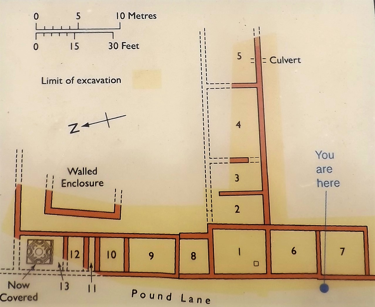
I have put together a map of the modern village illustrating the ruins that can be seen together with the church that holds other pieces of Roman archaeology discovered over the years and to which we headed last on our walk.
The blue arrows indicate our route and should help to orientate the reader as to where we were when the pictures were taken, as the map points referred to in the text are in the order we walked to them, not in a numerical one, focusing as we did in the better preserved southern wall.
 |
| The map illustrates the route (blue arrows) Mr Steve and I walked around the village with point markers to show important points pictured in this post |
Map Point 2 - The West Gate
Parking our cars at Point 1, the village car park and information centre we headed off to start our walk at Point 2, the west gate as illustrated in the impression below.

The base of one of the gate towers can be seen at this end of the wall leading south away from the road and one gets an immediate impression of the size of the structure which will only be added to as you walk on to the southern corner.
 |
| View looking south along the west wall from the base of the gate tower |
 |
| The base of the gate tower gives a vivid impression of the size of this structure and its likely appearance |
 |
| Looking back towards the road along the west wall |
 |
| The end of the western wall at its southern corner |

On turning the south west corner of the wall you get a really amazing site of the south wall stretching ahead as far as the eye can see with a series of bases of the four towers jutting out from it and with the ground in front dropping away giving a hint of the original vallum or town wall ditch that would have fronted the whole construction.
 |
| The view along the southern wall from the western corner and the extent of this wall is very impressive |
 |
| The base of the first of six projecting towers built on the southern wall |
 |
| The size of the base of the tower shows a significant structure and easily capable of mounting a small artillery piece such as a Scorpio bolt launcher |
 |
| A closer inspection of the wall construction illustrates an interesting herringbone pattern of laying the internal stones behind the facing stone work |
 |
| This wall is really impressive in its size and solidity, illustrated by its standing up to the ravages of time itself |
 |
| And still the wall progresses along the southern perimeter |
 |
| An illustration of one of the southern wall towers and the double ditch that would have fronted it |
 |
| One of the better preserved towers gives a great impression of the size and imposing nature of these defences |
 |
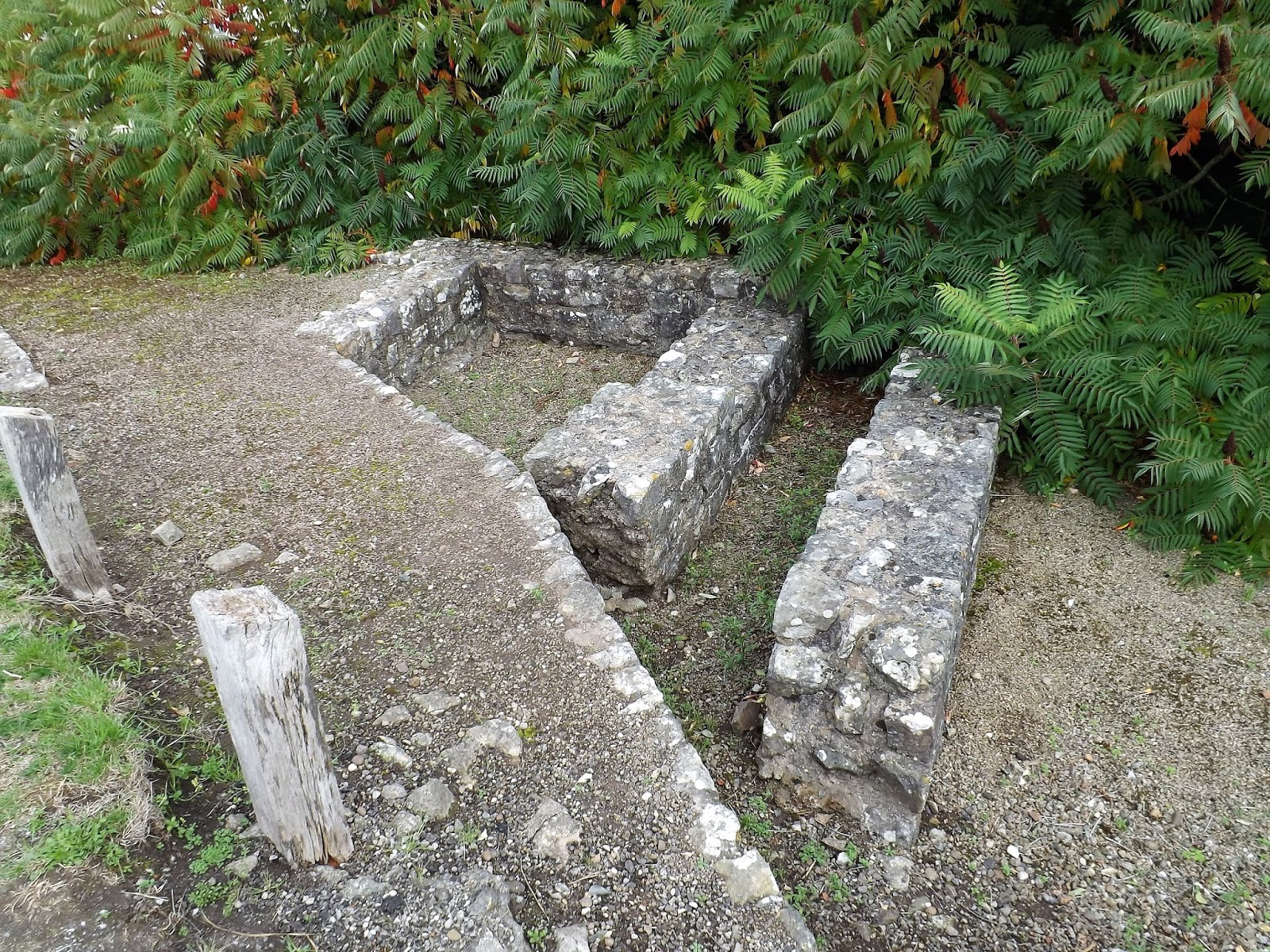
| A culvert leading out from the town's sewerage system feeding waste water into the town ditch |
 |
| Mr Steve stands in for an aggravated local tribesman, illustrating the height and solidity of the town defences |
 |
| The culvert channelling waste water from out of the town |
 |
| From the top of the southern wall one can see the protected land around the church covering up much of the remaining Roman archaeology of this amazing site |
 |
| The view out over the town of Venta Silurum from the southern wall looking west towards the hills beyond the valley |
Map Point 3 - The South Gate
 |
| The entrance at the southern gate and ground covering the original Roman road |
The south gate is marked by the track leading out through the gap in the wall which was most likely originally guarded by a tower gate similar to that illustrated for the west gate, except that both it and the north gate were single arches between the guard towers on either side.
Interestingly the Time Team program showed that the south and north gates were not directly opposite each other siting a Roman source suggesting that roads could be staggered in the layout of a town to reduce the effect of prevailing strong winds being channelled along them.
 |
| Ever onward it seems, the southern wall progresses from the south gate |
 |
| The base of one of the two towers on this half of the south wall |
Map Point 4 - Castle Mound
On reaching the south east corner of the wall another historical invader of the island has left their mark with a Norman motte built on the position and obviously taking advantage of the former Roman defences.
 |
| Ah the Normans, don't you just love them! |
 |
| An impression of the Norman motte and bailey castle built on the south east corner of the Roman town wall. |
 |
| Ignoring the vandalism of past centuries and the military needs of the Normans, the motte is still an impressive piece of military architecture |

As covered in the Time Team program, high status building such as villas were seemingly built at the extremities of the enclosure and in the corners of the defences thus being furthest away from the hustle and bustle of the town centre with its shops and businesses and greater population.
In 1777 the gloriously decorated mosaic seen below was discovered here in the south east corner of the town.
 |
| A mosaic floor discovered in 1777 in a building in the south east corner of the town |
 |
| Looking along the east wall from the motte on the south east corner |
 |
| The name of the road gives a clue to the ancient builders of this particular route into the modern village via the former east gate |
Map Point 6 - East Gate
At the east gate we decided to head back into the village and start our look at the building complexes that have been uncovered over previous years.
The east gate would have originally been guarded by a double arched gate between two towers similar to that illustrated for the west gate.
Investigation has discovered that the gates were not bonded into the wall which is thought to date from the third century and so they are thought to have been constructed earlier.
Opposite this gate, outside of the wall, a larger circular structure has been discovered, thought to have been a temple and you can see an impression of the building in the illustration of the town at the top of the post.

 |
| Looking along the east wall from the east gate |
Map Point 9 - The Temple
From point 6 at the east gate we made or way along the main road into the village and arrived at point 9 which marks the position of the remains of a Romano-Celtic temple built around 330 AD but the precise deity is uncertain.


Taking a road to our right led us to point 8, the town forum and the remains of nearby shops.
The illustration below gives an impression of the basilica which would have been the most imposing building in the town with high internal columns along the central nave supporting its lofted roof and forming the airy meeting hall for deciding town business.
The dimensions of the building measure 260 feet by 182 feet and is thought to have stood at least 65 feet in height and at either end of the central hall are the tribunal chambers where town magistrates would have their offices to hear civil cases.
The illustration of the west gate at the top of the post shows the basilica of the forum towering over the rest of the town.

 |
| A ground plan of the forum showing the arrangement of the buildings around a large central piazza entered through an archway from the main street to the left. |
 |
| The forum basilica looking over the back wall of the tribunal chambers along the nave with the north and south aisles either side of what would have been a row of columns supporting the high central roof |

 |
| The guttering marks the frontage of rows of likely food shops and taverns and surrounding a large open piazza in front of the basilica |

From the forum complex we headed off to point 12 to look at the remains of a courtyard house, illustrative of one of the higher status buildings built at the extremities of the town centre and close to the field where the Time Team discovered the villa complex together with its bath house.
 |
| Nicer more exclusive courtyard houses built on the outskirts of the town for the more affluent members of the community |
These courtyard buildings were uncovered between 1981-84 and show a series of three buildings built on the same site with the earliest construction, a timber framed house built on a lower stone foundation, built around the late 2nd early-3rd century.
The foundations on view are of the more substantial 4th century farm with well appointed rooms built around two courtyards and with the two main residential rooms on the northern side fitted out with hypercaust floor heating, painted wall plaster and mosaic floors.
 |
| Ground plan of the 4th century farm complex at point 12 |
 |
| A view of the foundations surrounding the two (grass covered) courtyards from the south side looking north as per the ground plan above |

From the courtyard farm we then went to points 11 and 10 with the former being part of a large three wing, courtyard house with painted plaster walls, hypercaust and mosaic floors and the latter consisting of shops, workshops and blacksmiths buildings.
These buildings were uncovered during excavations between 1947-55 and the large house revealed a series of reception rooms, dining room and servants quarters together with the mosaic seen below with fish motifs at each quarter now covered back up.
 |
| A 1958 illustration of the fourth century three wing courtyard house which is now thought to have been a single story building rather than the two stories as shown |
 |
| An illustration of the mosaic floor discovered in the courtyard house and now left in place but covered up |
 |
| The covered mosaic floor in the courtyard house area |
From the courtyard house this row of buildings extends into a series of commercial premises that appear to have been developed and subdivided over a period of time from 150 AD to about 350 AD producing a rather complex series of wall foundations.
 |
| The ground plan illustrating the development of this rather complex site of commercial buildings over two hundred years |
It is thought that two workshops were joined into one with one of these shown to be a blacksmiths workshop.
 |
| Looking from the courtyard house to the foundations of the commercial buildings leading out to the main road coming in from the west gate |


After musing over the confusing series of walls that marked the commercial buildings we then decided to conclude our visit to Caerwent with a look at the treasures held in the village church, just across the main road.
The Church of St Stephen and St Tathan holds some really interesting Roman finds made in the village over the years, plus I find it always fascinating to explore the local history retained in the monuments and memorials that churches contain, that often links the local to the national history.
 |
| The Paulinus Stone |
The Paulinus Stone is a really important find and a very interesting exhibit to be seen in the entrance to the church and indicative of the town dignitaries of a conquered tribe recognising the importance of cultivating a strong relationship with a patron to represent the town in the highest circles in Rome and the greater empire, as well as illustrating the joint role of military and civil administration for a Roman governor.

The stone was originally the base to a statue and the inscription was originally twelve lines but both the statue and the first line have been lost. It reads:
"(To Tiberius Claudius) Paulinus, (once) commander of the Second Augusta Legion, (next) proconsul of the province of Gallia Narbonensis, (now) imperial governor of the province of Lugdunensis; by decree of the council of the community of the state of the Silures."

Tiberius Claudius Paulinus was the legate of the II Augusta Legion at Caerleon during the reign of Caracalla 211-17. In 220 AD after serving in Gaul, he became governor of Britannia Inferior, the more northerly of the two provinces into which Britain had been divided at the beginning of the third century.
Before he became governor he performed some helpful act to the Silures, for which they honoured him by erecting a statue. In addition the inscription tells us that the Silures tribe were administered by a ruling council which could pass decrees, since the act of raising the statue was on behalf of the tribe of the Silures and not just the town of Venta, thus showing that a Roman civitas, for native people, should be seen as an area of territory with a town at its centre, rather than a town for Roman citizens with territory around it as a colonia would have been.
The stone was found in Caerwent in 1903 and had been reused as part of a post-Roman construction of heavy stone blocks in the centre of the village.
Next to the Paulinus stone was an altar stone excavated from the site of a house in Caerwent. The inscription reads:
"To the god Mars Ocelus, Aelius Augustinius, optio willingly and deservedly, fulfilled his vow"
Optio Aelius Augustinius was probably based at nearby Caerleon. Mars Ocelus was a particularly British if not a Silurian deity, indicative of the common fusion of beliefs which often occurred when native deities could be identified with their Roman equivalents.
These altar stones are quite common across the empire and I have now seen quite a few on my own travels and the typical small hollow on the top where an offering could have been placed or a sacrificial fire contained could be seen.

What was I saying about local history linking into national, and that was what caught my eye with this particular memorial seen below to Captain John Cropper, Royal Army Medical Corps drowned when H.M.H.S. Britannic was torpedoed or lost to a mine of Kea in the Agean Sea in 1916.
https://en.wikipedia.org/wiki/HMHS_Britannic
 |
| His Majesty's Hospital Ship Britannic pictured in 1916 |
Sadly for this class of unlucky ships and the poor souls who were on them when stricken, they remain the largest passenger ships on the seabed and the Britannic was the largest ship lost in the First World War.
Captain Cropper was particularly unfortunate in that of the 1065 people on board the Britannic when she foundered 1035 were rescued from lifeboats or the sea.


With the conclusion of our visit to St Stephen's and St Tathan I said goodbye to Mr Steve on this our second expedition with plans to look at some other interesting places to walk around and visit in 2019.
Thank you to everyone who has commented here and on other forums about how much they have enjoyed these kind of posts and I plan to continue having them as a major part of the blog, linking in as they do with the history underpinning the hobby as well as illustrating some of the great places to visit here in the UK.
Next up, a final look at my latest work on the second phase of terrain building and table preparations for forthcoming Romano-Dacian games and not forgetting my first unit of my Sarmatian cavalry division that can really spoil any Roman Saturnalia celebration.
Mr Steve’s ‘ Ever Popular Tours of Historic Wales’ will shortly be taking advance bookings for the new season and the guided trips will recommence as soon as the rain changes from cold to warm. For 2019 we have added in a host of new facts and topical anecdotes to help enhance your day , quite a few of which could even be true . We are also pleased to announce that our prices will remain at the 2018 rate of 1 Steak Pie and 1 Pint of excellent Ale. Book early to guarantee disappointment.
ReplyDeleteMy wife and I did the three castles and went to Caerwent afterwards. It is, to me ,one of the best ways to look at a Roman settlement - as you can get a real feel for its size and what was in it. I found the Norman Motte and Bailey quite small - time takes a toll but I found the same with others in the area (near white castle) so maybe it was just one that the put up for a short time as they moved along the old road? Anyway great days out
ReplyDelete